Thank you for taking the time to look at our interactive map on the United States’ alliance network. Above you will find a video guide on how to navigate the map that includes various insights from the map’s creators on both specific alliance agreements and broad alliance trends. For those that prefer written guides, see our written usage guide and FAQ below.
Usage Guide
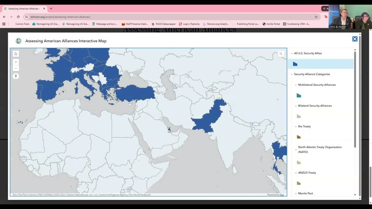
You can find the Assessing American Alliances Interactive Map on our main project page or view it on its own at this link. You can access and interact with the map on desktop or on mobile, though we recommend using a device with a larger screen, such as a computer or tablet.
As you open the map, you will see a popup window that gives a brief overview of the map contents.1As of the time of this guide’s publication, the map hosting service is experiencing a bug that does not allow users to manually reopen this introduction popup window. Until that bug is resolved, users must manually refresh the page to view this window again. Once that is resolved, users will be able to both permanently dismiss the popup and manually reopen it via an information button in the top right corner of the map screen. This popup window will be updated to include the current release version of the map, the most recent date any data was updated, and the best way to reach the team for feedback or to report an issue with the map’s data or functionality. Dismissing this window will bring you to the default view of the map and allow you to begin interacting with its contents.
Default View
The default view of the map shows the entire globe and has all included categories selected, though many are not initially visible, as they are covered by the main “parent” category, “All U.S. Security Allies.” This main category colors every country in blue that has at least one written agreement with the United States (usually a treaty, but occasionally an executive agreement) that contains an explicit U.S. defense commitment, hereinafter referred to as security alliance agreements. The remaining visible categories (in shades of purple) include individual security-related agreements that do not contain an explicit U.S. defense commitment, nor are exclusively arms sales agreements, but are comprehensive enough to be deemed notable. Additional agreements in the “Other” grouping may be added in future map updates.
Interactive Legend & Category Groupings
Clicking or tapping on any of the categories in the legend will toggle them on or off on the map.2The map legend is fixed on the right side of the screen on desktop and at the bottom of the screen on mobile. The colors are layered on the map in the order they appear on the legend, which functionally means:
- To properly isolate any one category on the map, you should unselect at least every category listed above it in the legend. Best practice is to unselect all but the one category.
- If a country is included in multiple categories, the selected category that is highest on the legend will determine the color visible on the map. For example: Canada has both bilateral and multilateral security alliance agreements with the United States. If just those two categories are selected, Canada will be colored as multilateral (teal), as that category comes first in the legend. Toggle the multilateral category off, and Canada will be colored as bilateral (light green).
In addition to the main “All U.S. Security Allies” category at the very top, the rest of the legend contains two main sub-groups: “Security Alliance Categories” and “Other.”
“Security Alliance Categories” contains various groupings that collectively make up the “All U.S. Security Allies” category. This includes multilateral versus bilateral agreements, as well as individual multilateral agreements (i.e. NATO, Rio Treaty, etc.).
The “Other” category grouping is fully separate from the earlier categories and contains notable security-related agreements that lack a defense commitment requirement. Categories included in Version 1.0 of the map are Major Non-NATO Ally (MNNA) status and signatories to the Charter of the Organization of American States (OAS).
Individual Country & Historical Information
Clicking or tapping on a specific country pulls up a popup box with the following categories:
- Full Name
- Active Security Alliance Agreements3Includes a list of all security alliance agreements that the selected country is party to in the current day. Each agreement name is followed by the year it was entered into force.
- Other Active Agreements4Includes a list of all agreements from the “Other” category that the selected country is party to in the current day. Upon the launch of this map, those categories are MNNA status and OAS Charter signatory. Each agreement name is followed by the year it was entered into force.
- Archive Security Alliance Agreements5Includes a list of all historical agreements since 1900 that meet the threshold for a security alliance agreement but are no longer enforceable after being dissolved, rendered obsolete, denounced by the selected member country, or denounced by the United States. Each agreement name is followed by the year it was entered into force, the reason it is no longer active, and the year it became inactive.
- Description6Provides an overview of the current and historical relationship between the selected country and the United States, covering all agreements in the above categories and outlining any relevant nuance or complications.
All active agreements listed in the above categories are visually reflected in the map, but “Archive Security Alliance Agreements” includes all security alliance agreements made since the year 1900 that are no longer in force and thus do not appear on the map. The first agreement that meets this threshold is the Four Power Treaty, entered into force in 1923 and terminated in 1931. Explore the map and individual country descriptions to see more information about this and other inactive security alliance agreements.
Map Navigation & Technical Features
The entire map frame can be dragged or zoomed in/out at any time to help you view features more clearly. Zooming in populates that portion of the map with increasingly granular labels and geographic divisions to help you better distinguish between locations. There are also various buttons around the screen with useful functionalities, listed and described below:
Top Right (from top to bottom)
- Home Button – Resets the map zoom, frame, and orientation to the default state.
- Plus/Minus Buttons – Adjusts map zoom in or out.
- Compass Button – Shows current map orientation and resets to the default orientation when clicked.
Top Left (from top to bottom)
- Search Button – Opens a search bar that allows you to locate and zoom in on a specific location or region.
- Keyboard Button – Opens a list of keyboard shortcuts that can aid you in navigating the map.
Country Popup Box
- If you click a country from too far away or near a border, there will be an extra row at the top that says, “1 of __” on the right side. The arrows on the left side let you navigate between countries and the list icon on the right side will pull up a list of all countries close to your selected point. The currently selected country will be outlined in bright blue on the map and be named in the second row of the box.
- In the row with the country name, there are three buttons on the right side. From left to right, these are:
- Window Button – This swaps the popup between being in docked mode (static on the top right of the map) and standard popup mode (appearing next to the selected country on the map).
- ^ Button – Collapses the popup box without full closing it. Use this if you want to briefly get a better look at the obscured portion of the map.
- x Button – Closes the popup window.
FAQ
What is a “Security Alliance Agreement”?
For the purpose of this map, we define a security alliance agreement as a written agreement (either a ratified treaty or a signed executive agreement) between the United States and one or more other countries that clearly obligates the United States to defend or attack another country, area, or region not under U.S. control. These can be — and often are — mutual defense agreements, but we do not require the defense obligations to be mutual for them to appear on the map as a “security alliance agreement.” There are also no restrictions on whether the agreement is limited or broad in scope.
Notably, this category does not include agreements on consultation, non-aggression/neutrality, basing access, or arms sales, unless it separately includes a clear offense/defense requirement.
Where is your data from?
We curated our own dataset from a variety of sources, primarily Rice University’s Alliance Treaty Obligations and Provisions (ATOP) project (v5.1), which includes global alliance data from 1815 to 2018.7Leeds, Brett Ashley, Jeffrey M. Ritter, Sara McLaughlin Mitchell, and Andrew G. Long. 2002. Alliance Treaty Obligations and Provisions, 1815-1944. International Interactions 28: 237-260. All ATOP data was cross referenced with the Correlates of War’s Formal Alliances dataset (v4.1) and the original cited treaty/executive agreement documents.8Gibler, Douglas M. 2009. International military alliances, 1648-2008. CQ Press. For agreements newer than 2018, information was sourced from official government websites and original agreement documents. These official sources were also referenced to determine entry into force dates for all included agreements.
How often is your data updated?
Data is updated periodically as new alliance partnerships arise or existing partnerships end. A minor data edit or individual agreement update will be listed as a “Partial Update” with the corresponding month and year in the introductory popup window of the map. A complete data review/update will occur roughly once a year and be referred to as a “Full Audit” in the introductory popup window.
Will you include new data categories in future updates?
We may add new data categories in the future, pursuant to user interest. If you would like to suggest new features for future updates or provide other feedback on the map, please fill out our feedback form here.


Current Geopolitics Shift Deep-Sea Mining Debates