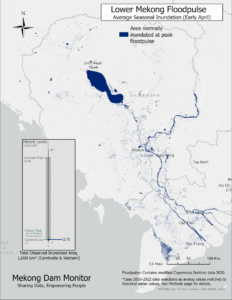
River levels on the Mekong continue to be severely low. This image shows a section of the Mekong mainstream with Thailand’s Loei province on the south and Laos’s Vientiane province on the north. See how so much more of the riverbed and islands and shoals of the mainstream are exposed in late November 2019 compared to a normal late November in 2017. The low river levels are caused by an extended drought which basically supplanted this year’s monsoon season. More than fifty dams upstream in Laos and China also contribute to low levels and the incremental effect of the recently opened Xayaburi Dam, a few hundred kilometers upstream, is certain but unknown. Note how the 2019 river color is much bluer or cleaner than 2017. Drought has brought less runoff into the river system this year and the Xayaburi dam upstream holds back sediment. In turn, the muddy Mekong is turning from its normal brown to blue. This is not good – sediment is the critical building block of downstream agricultural productivity in Laos, Cambodia, and Vietnam and is necessary to produce the Mekong’s annual 2.6 million ton fish catch, the largest in the world for a single river.
- Trade
& TechnologySecurity
& StrategyHuman Security
& GovernanceClimate
& Natural Resources - About StimsonTransparencyPeople
- Find ResearchResearch, programs and projects, events, and institutional information.Find ExpertsStaff and affiliates by name or research area.


