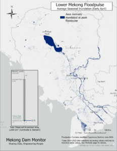
Nearly 170 hydropower dams in the Mekong Basin are driving the once-mighty Mekong river toward a deep erosion of its natural resource base from which tens of millions of people in Cambodia, Lao PDR, Thailand, Vietnam, and China derive daily food and water resources. Plans for hundreds of additional hydropower and irrigation dams could push Mekong economies and the region itself toward crisis. This StoryMap gives an overview of the current state of dam development in the Mekong Basin and provides policy recommendations to mitigate unfolding environmental and social impacts as well as identifies pathways to avoiding future risk. ArcGIS StoryMaps are web-based applications that combine narrative storytelling with integrated and interactive maps and other embedded content. StoryMaps are supported by Esri which is the global market leader for geographic information systems and a partner of the Mekong Infrastructure Tracker platform.


