Introduction
The Mekong Dam Monitor (MDM) uses satellite imagery and remote sensing data to understand how the operations of the 60 largest dams in the Mekong Basin alter the river’s natural resources and reduce the ecological and social functions of core natural features such as the Tonle Sap Lake in Cambodia, the world’s largest inland fishery. This effort is important because prior to the MDM’s 2020 launch, Mekong researchers and communities living along the river’s mainstream, tributaries, lakes, and wetlands knew the Mekong’s annual flood pulse was weakening and noted a reduction in fisheries and other natural resources, but the causes of change were mostly matters of speculation.
It was known broadly that China had the largest dams, but one could not pinpoint the impacts to either individual dams or the cumulative impacts of hundreds of operational dams throughout the basin because China and the lower Mekong countries shared no information about the operations or status of dams. The political discourse around data sharing among Mekong countries remains complex, but in 2020 all Mekong countries were having a conversation about some sort of data sharing. As an external provider of data and information, we saw an opportunity for the MDM to use science to inform policy making and support a constructive discourse to catalyze more data sharing across borders. The MDM could also play an enabling role to advance transboundary water governance and inspire investments that build resilience among the Mekong’s most vulnerable communities and in its most critical ecological features amid a changing climate.
Today, Lower Mekong governments are now sharing dam data with each other through the Mekong River Commission, and in September 2023, China for the first time pledged to share its dam operations data with downstream countries. Collaboration between the Mekong River Commission and China’s Lancang-Mekong Water Resources Center (China’s MRC counterpart) is strengthening and both sides are now committed to the joint operation of dams to sustainably manage the river’s resources. Yet goals and objectives of future joint operations remain unclear. Our efforts have helped prioritize the protection and conservation of key features like the Mekong Floodpulse, which benefits all peoples and living beings of the Mekong and enabled the evolution and strengthening of MRC protocols which are tuned to protect the flood pulse. Our efforts tell the story of a huge transboundary watershed which runs 4,000 kilometers through six incredibly diverse countries from the Tibetan Plateau to the South China Sea. Those who follow the story tell us they feel in tune with the river’s energy, its needs, and its changes.
This report overviews the MDM’s achievements and adaptive strategies employed by the project team since the platform launched in December 2020. The first section highlights best practices developed through consultative, co-designed processes with key government and non-government stakeholders active in the Mekong Basin. The second section discusses lessons learned as the project team improved its methods and localized the MDM’s services and outputs. This section also explores the limitations of external data and information providers like us and remote sensing imagery. The third section reviews key achievements and outcomes, while the fourth and final section discusses work which remains to be done and charts out new horizons that could be explored in the future through new possible partnerships.
This report is written with the general Mekong watching community in mind as an audience, and it provides insight to those who are considering work in the remote sensing and river monitoring space, whether in the Mekong or in other watersheds around the world. Rivers across the globe face unprecedented challenges and need protection. It is our hope that the MDM can inspire others to use remote sensing and earth observation to bring science-based evidence into natural resource conservation, climate resilience, and disaster risk reductions discourses around the world.
Best Practices
Develop Parallel, Redundant Methods to Build Trust
Use of remote sensing methods and satellite imagery to understand the operations of the largest Mekong dams and the changes that these dams and climate variability bring to the Mekong Basin is still a novel process, one which still is thinly understood among the stakeholders throughout the basin and around the world. We have found that when working in novel, sensitive spaces, it is necessary to use integrated, parallel, and sometimes redundant processes to turn science to evidence in order to tell a coherent story and deliver impactful analysis that inspires better policy.
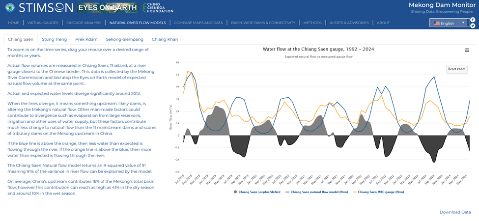
The Mekong River Commission (MRC) curates and publishes an extensive dataset of hydrological indicators, spanning decades (and in some cases over a century) and covering much of the basin in the four MRC member countries of Thailand, Laos, Cambodia, and Vietnam. This data, co-produced by MRC member countries under the auspices of the 1995 Mekong Agreement, is widely socialized and accepted by stakeholders working on transboundary water governance issues in the Mekong. Whenever possible, we integrate our satellite-derived data with MRC’s publicly available data. This enables the MDM to track the impacts of dams from the Golden Triangle to Stung Treng, Cambodia covering a long span of the river. MRC data also enables the determination of baselines such as a normal floodpulse pattern and the dividing line between when the river ran mostly unimpeded before the effects of the largest dams. These baselines are important when trying to demonstrate change over time and when establishing targets for conservation or restoration of the river’s natural processes (through joint operations or other adaptive interventions to improve resilience). What the MDM team does best is use its toolkit to monitor the operations of dams and their impacts to the Mekong’s natural hydrological flow. Yet the 60 dams monitored are located across a huge space thousands of kilometers apart. Despite large demand for insight into the operations and impact of these dams, governments are hesitant to officially share data. At the same time, while satellite-derived data is available, it may not be understood, believed, or presented in an actionable way. To address these concerns and boost confidence in the information we provide, we built parallel processes and redundancy into the MDM and use multiple data sources (such as both microwave and synthetic aperture radar (SAR)) to tell the story and verify analysis. For example, our natural flow models show when water is being restricted or released by upstream dams and can demonstrate the impact of these dam operations to a downstream gauge, while our virtual gauges use a separate process to monitor changing water levels and volumes of individual dams and compare their cumulative restrictions or releases to what is observed at downstream gauges. Seeing is believing: On the virtual gauge page for each dam, users can actually see the image of the reservoirs and compare against previous images to view how levels change over time.
Natural Flow Model

Virtual Gauge
We further apply our commitment to parallel, redundant processes when monitoring critical ecological features of the Mekong Basin. After consultation with stakeholders in Cambodia, in 2022 we began to monitor the natural, seasonal flooding processes of the large, shared floodplain between Cambodia and Vietnam. For the first time, it was possible to monitor the status of the Tonle Sap’s wet season expansion and water availability in Vietnam’s Mekong delta in real time. This was an important advancement because the Tonle Sap’s seasonal expansion drives the fisheries productivity of the entire lower Mekong, which is responsible for around 15% of the planet’s freshwater fish catch. Monitoring water availability in the Mekong delta can help decision makers and farmers in Vietnam in dry season irrigation and agricultural planning. As with dam monitoring, we use both microwave data and SAR data to tell similar stories and visualize the dynamism of these important ecological features. The SAR imagery visualizes areas flooded with seasonal inundation at a very high resolution, while the microwave imagery shows how wet the surface of the earth is at a much lower resolution. Combined, these two methods provide a powerful picture of what is happening and forecast changes to come in the lower basin.
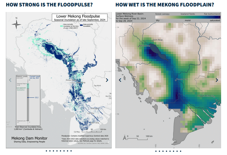
Parallel Methods Tell the Same Story, Differently
These parallel processes have enabled much learning. The SAR-derived floodpulse maps show in high resolution how canals, cities, towns, and other infrastructure are disconnecting the Mekong’s natural floodplain. The SAR-derived floodpulse maps compare the current level of seasonal inundation to a historical baseline, which gives insight into the strength and timing of the floodpulse – two factors which are known to drive the Mekong’s robust fishery. But what the SAR-derived floodpulse maps cannot show is what drives the expansion of the lake. Prior to our efforts, it was long assumed that most of the lake’s expansion comes from the reverse flow phenomenon, driving water from the Mekong upstream into the Tonle Sap. However, our Tonle Sap natural flow model has shed light on the ability of significant precipitation over the lake’s watershed to drive the expansion process. We explored this major find and the methods behind the Tonle Sap natural flow model in the Deep Dives section of our last annual report.
Build a Flexible, Adaptable Toolkit Ready for New Challenges
Much of what you can see and explore today on the MDM was not part of the project’s initial design. Over time, we worked with civil society, government stakeholders, and the Mekong watching community to co-develop features and services to meet newly identified needs and interests such as those discussed below.
The MDM’s early warning service for sudden dam releases and restrictions benefits tens of thousands of people living along the Thai-Lao border from the Golden Triangle to Vientiane/Nong Khai. Prior to this service, local people had no warning for sudden rises in the river’s level caused by China’s upstream dams, which in some cases could cause flash flooding lasting for days causing harm to individuals and their livelihoods. Civil society organizations (CSOs) had long communicated the need for an early warning system to the Stimson Center, so when the first sudden and significant change in river level showed up in the data just three weeks after the MDM launch, the team confirmed this change was a result of a dam operation in China and issued its first early warning to the Thai government, the Mekong River Commission, and to CSOs who shared the warning throughout their local community networks. This warning and its positive benefits were covered in the local and regional media. Since then, the MDM team has issued more than 80 early warnings which reach vulnerable communities 2-5 days before the river level changes hit them. Vulnerable people living along the Thai-Lao border receive these warnings through targeted messaging on our Facebook page, where we use a portion of our funding to promote alert messages to people living in identified communities. We have collected numerous testimonials from people who say their crops and boats are protected by these warnings, as well as boat drivers who tell us the warnings help them navigate the river and downstream dam operators who say the warnings help them more safely operate their dams. More achievements and positive behavior changes that have resulted from the early warnings are discussed later in this report.
When launched, the MDM monitored the operations of dams in each of the Mekong countries and provided a weekly view of surface wetness, temperature, and snow cover change throughout the entire basin. But our initial analysis largely focused on how dams and climate change were impacting the river along the Thai-Lao border at places like Chiang Saen in Thailand’s Chiang Rai province. However, the Mekong’s population and natural resource provision becomes larger and denser in the downstream countries of Cambodia and Vietnam, and MDM users there including government officials and the public alike requested more analysis of dam impacts in their countries and communities. This led to the development of the floodpulse and Tonle Sap monitoring processes discussed above and much more insight over the impacts of dam and climate change to these important features.
At the same time, Cambodians were curious to know more about the impacts of dams in Laos and Vietnam on the Sekong, Sesan, and Srepok Rivers (collectively known as the 3S Rivers) to downstream communities in Cambodia’s Ratanakiri and Mondulkiri provinces. Other Mekong watchers and scientists questioned whether there was sufficient water in existing reservoirs of the 3S Basin to offset some damage that upstream dams were causing to the Tonle Sap Lake’s natural flooding process. These requests led to the real-time monitoring of 20 new dams in the 3S Basin in Laos and Vietnam and a greatly improved understanding of how these dams impact the natural flow of their respective tributaries and the Mekong mainstream. Key takeaways are explained in this report, but in summary: the overall impact of these dams is lower than dams upstream, but there is a need for a transboundary early warning system for sudden dam releases between Vietnam and Cambodia and a need for improved physical gauges along the course of these tributary rivers.
Another innovation from our 3S Basin work was the development of a real-time cascade analysis feature for groupings of dams in different parts of the basin. Users and practitioners can now see how China’s upper cascade of 12 dams is operated in concert to maximize power generation. These observations can be applied to hydropower cascades such as those in the transboundary 3S Basin and provide an opportunity for the governments of Laos, Cambodia, and Vietnam to jointly operate these dams in a more effective and sustainable manner.
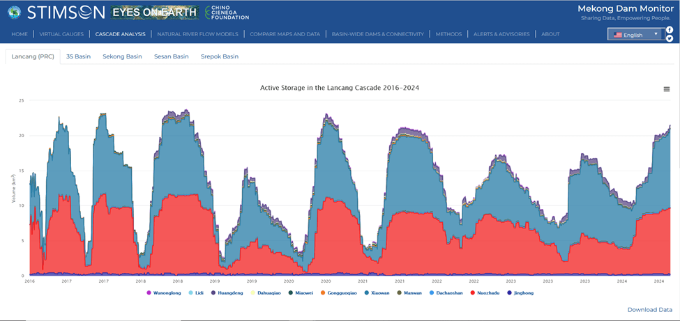
Cascade Analysis
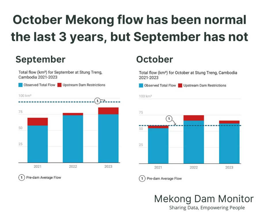
Last year, we extended our dam and climate impact analysis—previously applied only to Chiang Saen, Thailand—to cover nearly the entirety of river’s span through Stung Treng, Cambodia. Analysis and a more robust explanation of this new service is covered in our 2022-2023 Annual Report, but this service has led to the following major insights:
- At times, the operations of the largest dams in Laos can be as impactful if not more impactful than China’s large dams.
- The area of the Mekong Basin around Nakhon Phanom, Thailand is doubly affected by the impacts of China’s dams and Laos’s large dams, and these impacts need to be further studied.
- The cumulative impacts of dams in the Mekong Basin can reduce wet season flow in certain months by as much as 17% and double dry season flow in certain months to Stung Treng, Cambodia (far downstream). Both effects have severely negative ecological and socio-economic consequences.
- The negative wet season effects of upstream dam restrictions are the most pronounced when the wet season is experiencing low levels of rainfall, and as such wet season upstream dam restrictions should be moderated or avoided when rainfall is lower than normal in order to avoid the worst consequences of the cumulative impacts of drought and dam operations.
Develop a Multi-Modal Communication and Engagement Strategy to Achieve Impact
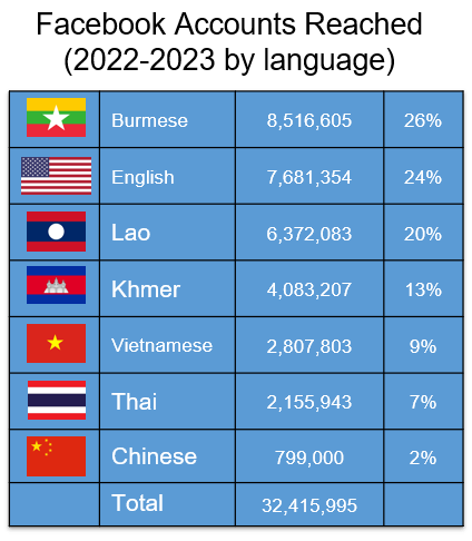
Only a small portion of our user engagement comes from users directly accessing the MDM platform. Most of our information is consumed through weekly social media postings, emails, and recorded webinars available on the Stimson website and YouTube. Social media can be extremely impactful in getting a story out and raising awareness around an issue. More than one million Facebook users per month access and interact with our social media products, and this has done much to encourage communication with social media users across national boundaries and generate focus on issues within local language groups. Key actors such as government officials are often active on social media platforms which provide a venue for these actors to share and respond to new findings in real time.
In addition to a subscription-based English language email update, we issue email updates in local languages to curated groups of government officials in Cambodia, Laos, Vietnam, and Thailand. The number of officials receiving these updates in local languages has steadily increased over time and the emails offer an opportunity for online communication and a touchstone for in-person engagement.
We have found that our seasonal “Where’s the Water” webinar series (offered with simultaneous interpretation in all six Mekong languages) and our ongoing “Mekong Water Data Hour” webinar series serve as useful resources that drive journalism, catalyze new research, and help keep the Mekong watching community updated. These webinars convene people working on Mekong issues around the world and put a human face on what otherwise is mostly a digital, data-driven effort.
Behind the scenes, the team is busy answering requests for briefings from CSOs, government agencies, journalists, and international partners and providing walkthroughs or virtual tours of the MDM to concerned parties. Collectively, the team convenes several briefings and walkthroughs each month to interested audiences around the world.
Finally, as more scientists and professionals throughout the Mekong become interested in these methods, the team has become active in teaching the MDM toolbox to build capacity for partnerships or new innovative methods of water and climate monitoring in the Mekong. Over the last year, the team has held remote sensing capacity building workshops hosted by the Institute of Technology Cambodia and Chiang Mai University. These workshops were sponsored by the U.S. Department of Interior’s Ambassador’s Water Expert Program and each has resulted in the development of new, co-collaborative projects that can deliver positive impact to the sustainable development of the basin.
Lessons Learned
Know Your Position
Figuring out our positioning as a third-party provider of entirely new information. The MDM is a non-governmental, third-party effort using new technology to drive change in a complex political landscape. When the effort began, we were locked down in our homes during the early pandemic. Navigating our position as external data and information providers was bound to be difficult and still requires awareness and sensitivity. To find our way, we stuck to our core mission of monitoring and communicating the impacts of dams, and after the MDM launch the only new features added were ones requested by people in the Mekong Basin. We constantly communicate with a range of key actors in the region, observe how key stakeholders react when trialing new services and products, and let their feedback guide us. We also let the local market lead the way, taking on newly funded tasks designed for local impact. In January 2022, the Mekong River Commission published our data and findings in an official report on causes of recent low flows in the Mekong Basin. The report explained how our data and information was useful and discussed its limits. This sign showed that we were on the right path.
Know Your Audience
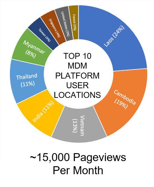
Early on, we envisioned millions of users from government officials to fishers on the Tonle Sap to journalists to the curious environmentalist and more logging onto the MDM platform via their laptops or smartphone. That didn’t happen. When the platform launched, we got on average 3,000 users per month. This sparked internal discussion and a rethink. How could we reach our audience better? Who could we reach to achieve the impact we sought? How to best ensure that the data we provided was accessible and actionable? Over time, we realized that we initially designed the MDM platform mostly for dedicated Mekong watchers, with tabs and features and deep data archives that could answer some of the Mekong’s most pressing questions. And to date, the MDM platform gets around 15,000 hits per month with about one thousand returning users – a core group of Mekong watchers who come from the MRC, Mekong government agencies, CSOs, academic, and media outlets.
Who Uses the MDM Web Platform?
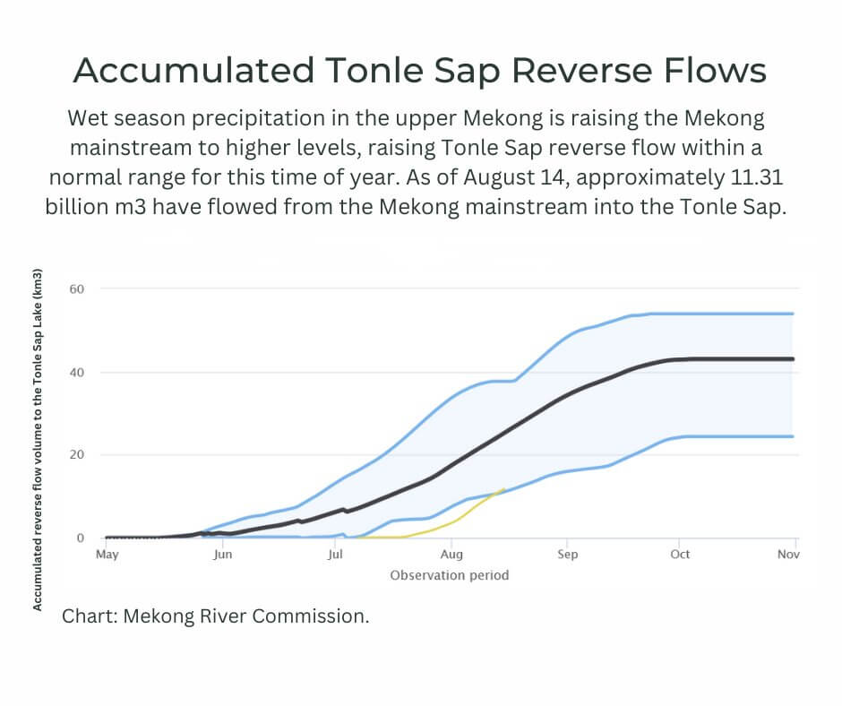
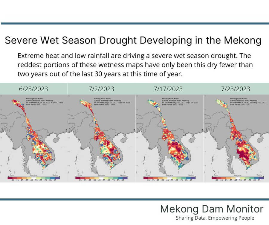
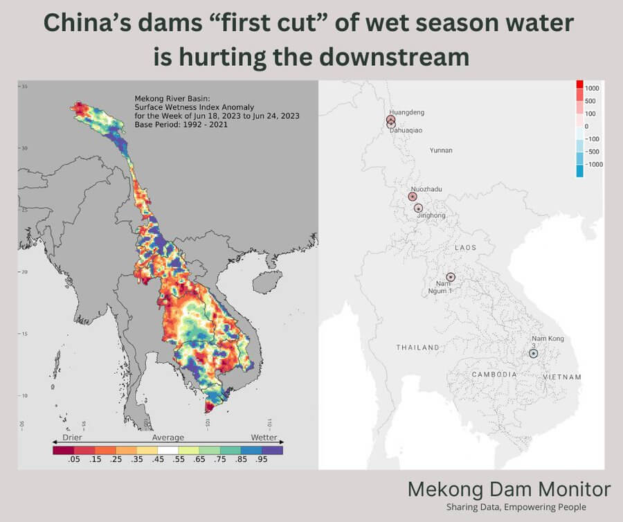
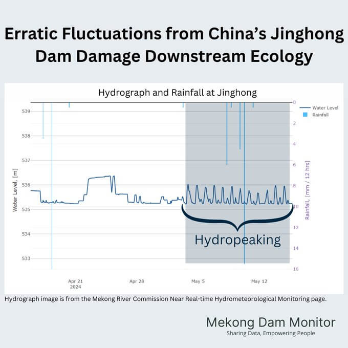
But we also felt the data presented an important story to tell to the general public, and this led to the development of easy-to-digest, local language social media products designed with GIF animations and colorful infographics to point to the Mekong’s most pressing issues of the day. Some of the most viewed infographics are displayed below.


We also redesigned the MDM landing page from a complicated list of information about particular dams to an easy-to-digest set of visualizations organized around a series of questions such as “How much water is in reservoirs by country?” “How strong is the floodpulse?” and “What should river levels be?” This redesign was concurrent with the introduction of local language social media products translated by local consultants into the six national Mekong languages, which drove new users to a platform now entirely translated into local languages. After making this change, platform usage increased from 3,000 hits per month to 15,000 and the frequency of MDM media and peer-review journal mentions increased. Social media hits increased from 7,000 per month to more than one million per month on average.
However, learning who our audience is also made us realize who our audience is not. While we hoped that people living in affected communities along the river would serve as a major audience grouping, we have realized that communicating generalized information which covers a broad range of issues across the entire Mekong Basin likely is not the best approach to reach the vulnerable fisher or farmer. To be sure, our targeted early warnings (discussed above) for sudden dam releases do reach these vulnerable peoples, and this can provide insight into the kind of actionable and specific information demanded by vulnerable peoples and local actors. Consultations with people living in affected communities show they want to know whether they can fish or plant their fields tomorrow or how they can best prepare for severe weather events. They also want to know how people in the communities surrounding them are experiencing and adapting to change. The MDM could be tuned to this kind of hyper-localized communication with more resources, but the needs of these local audiences likely are better served by efforts designed to inform a more targeted national or subnational scope. Such limits and further prospects for useful interventions are discussed below.
Show Your Work
From the start, we shared the code needed to understand and replicate our processes and fully explained the methods used to generate data and information published on the MDM platform. We openly discussed levels of confidence in the accuracy of our measurements. While some inputs we use, such as digital elevation models, are not perfect, and the spatial and temporal resolution of our inputs vary, we are filling data gaps that were previously unknown. Stakeholders and users of our data often communicate with us to point out possible issues such as through sending timestamped photographs of reservoir levels while on field visits or interrogating our methods for calculating baselines. All of this constructive information provided by the Mekong watching community allows us to reflect on our methods, and at times recalibrate and improve. Showing our work allows the methods to speak for themselves and provides a platform for innovating and increasing accuracy.
Localize But Do No Harm
A chief ingredient of our recipe for success is publishing information and storytelling in the six national languages of the Mekong: Burmese, Chinese, Khmer, Lao, Thai, and Vietnamese. MDM products and analysis are not only translated, but the team has worked hard to communicate in a language that resonates with local stakeholders and focuses on issues with which they can identify. Before we launch a new visualization product such as the Mekong floodpulse map, we work for weeks or even months to workshop with local stakeholders over the design and language used to explain what the visualization says. Our efforts and methods to appeal to a local user base can always improve, but at the same time we are committed to localizing in a way that does no harm to local stakeholders.
From the start of our efforts, we have looked for co-owners and research partners who can directly support the work of the MDM from within the Mekong basin. We have also explored passing the MDM off to key government and intergovernmental institutions active in this space. While we are getting closer to potential partnerships, we have not yet landed on a sustainable modality that can protect partners. The use of remotely sensed and earth observation data for official purposes is still not authorized in some Mekong countries and can put its practitioners in sticky legal straits or raise possible conflicts of interest. For now, we will continue to search for ways to localize without doing harm to partners while remaining a trusted, third-party provider of data and information working for the protection and conservation of the Mekong’s natural resources.
Key Project Achievements and Outcomes
Since launch, the Mekong Dam Monitor has served as an example of a constructive, non-government initiative promoting transparency, science-based evidence for impact, and public engagement in the Mekong Region as part of the Mekong-U.S. Partnership’s Mekong Water Data Initiative. This section reviews some of the achievements and outcomes directly or indirectly brought about by the MDM’s efforts.
A Positive Case for Science Diplomacy
The MDM’s positive impact has been the subject of speeches given by a U.S. Secretary of State and Assistant Secretaries of State and is often mentioned in public speeches made by US Ambassadors and diplomats active in the region. In December 2022, MDM co-lead Brian Eyler testified before the U.S. House of Representatives Subcommittee on Foreign Affairs-Asia Pacific on the positive impacts the MDM has brought to the Mekong Region and US foreign policy efforts in the Mekong. In November 2023, a bipartisan US Senate resolution co-sponsored by Senators Jeff Merkley (D-OR) and Dan Sullivan (R-AK) on US government engagement in the Mekong cited the positive impacts of the MDM and several key points of analysis including the negative impacts of China’s dams on downstream ecological processes.
Use Cases in All Mekong Governments and the Mekong River Commission
MDM data now has confirmed use cases in all Mekong governments as well as the Mekong River Commission. Government stakeholders have demonstrated to the project team how they frequently share and discuss MDM data and information in their internal communications with other agencies. MDM visualizations and data are often cited in official government presentations linking the impacts of upstream dams to the reduction of the Mekong’s natural resource base. During the MDM’s buildout period, government agencies in Thailand and Vietnam accepted invitations to take part in consultative meetings to assist with co-design elements. These governments consequently provided endorsement of the MDM upon launch. Through engagement efforts government stakeholders in Cambodia and Laos have also become core users, and online engagement statistics show that the cities with the most users accessing the MDM platform are Vientiane, Laos and Phnom Penh, Cambodia, each with about 2,000 users per month.
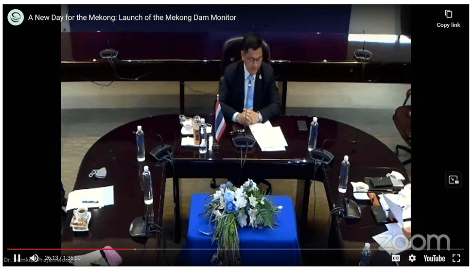
Thailand General Secretary Somkiat Prajamwong speaks at the virtual launch of the Mekong Dam Monitor in December 2020.
Vientiane is home to the Mekong River Commission Secretariat, where the MDM’s largest user base for a single institution likely originates. The MDM team frequently shares its findings with key stakeholders at the MRC in an informal capacity, and the MRC frequently comments on the positive uses of MDM data. In communicating with the MRC, the MDM team focuses on cases where data reveals that member countries may not be following agreed upon protocols of the 1995 Mekong Agreement (such as notification on the construction of new dams); useful information about the status of operations of China’s dams, including dams which have begun construction or have begun to fill their reservoirs as in the case of the Tuoba Dam; and advice to pass along to member countries regarding how to better operate dams in near-real time in order to reduce damage to the Tonle Sap Lake and the Mekong Floodpulse. In March 2022, the MRC published MDM data and analysis as part of a study on the causes of low Mekong River flows across the 2019-2021 period which showed the causal effect that upstream dams have on reduced wet season flows and increased dry season flows.
The MDM Encourages Governments to Share More Data
Official data sharing across borders in the Mekong is still a work in progress. In 2024 the MRC member governments are sharing more data through agreed upon protocols than they did in 2020, and China has increased its data sharing with the MRC as well. We believe the MDM has helped quicken the process of data sharing. Prior to the launch of the MDM, only Thailand shared daily information about the status of its large hydropower dams on a public website. Now Vietnam’s national utility EVN provides hourly updates on the status of most of its large hydropower dams including more than 15 in the Mekong Basin on a public websitee. EDL-Gen, the government owner and operator of 10 dams in Laos, also now shares daily information on the status of these dams on a public facing website. And for a short-lived window of five weeks in 2023, EDL-Gen shared pdfs with relevant dam operations data for more than 60 dams in Laos on its public facing Facebook page.
MDM efforts have helped motivate increased and improved communication between China and downstream countries. China now sends data updates to governments party to the 1995 Mekong Agreement (Thailand, Laos, Cambodia, Vietnam) and the Mekong River Commission Secretariat on river levels at the Jinghong and Man’an gauge at 12-hour intervals. Previously China had only updated its hourly data once every 24 hours. Providing data at 12-hour intervals improves the ability to monitor sudden releases and restrictions from dams upstream of these river gauges and provides vulnerable communities with more time to adapt to these sudden changes. In September 2023 at a joint Mekong River Commission-Lancang Mekong Cooperation Mechanism meeting, China also pledged to share dam operations data by the end of the calendar year. This pledge was to be realized by the end of the 2023 calendar year but has yet to translate into action.
Contributions to Improved MRC Processes
The MDM’s constant scanning and reporting on dams and their impacts throughout the Mekong Basin has led to improvements and evolution of MRC processes. As parties to the 1995 Mekong Agreement, all member countries are to adhere to the Prior Notification, Prior Consultation, and Agreement (PNPCA) Protocol which requires member countries to notify the MRC Secretariat when new dams begin construction in their respective portion of the Mekong Basin (on both tributaries and the mainstream). In late 2021, the MDM team discovered via satellite optical imagery analysis that construction had begun on the Sekong A Dam in southern Laos in December 2020 and shared this information publicly. Building a dam across the Sekong River would have significant impacts by blocking the last long fish migration pathway from the Tonle Sap through a major Mekong tributary. Most other long tributaries of the Mekong, and particularly those close to the Tonle Sap Lake, had already been dammed and had thus lost their connectivity for fish migration. In August 2022, Lao government provided notification to the MRC which then led to a voluntarily application of a Transboundary Environmental Impact Assessment (TbEIA) for the Sekong A Dam. This was the first time a TbEIA had been agreed to and applied for a Mekong dam project, and its implementation will set a precedent for future dams with significant and obvious transboundary impacts. The TbEIA for the Sekong A Dam remains in draft format, but initial findings state that the dam’s fisheries impacts are significant and recommend a total redesign of the dam and its mitigation efforts if fisheries losses are to be minimized.
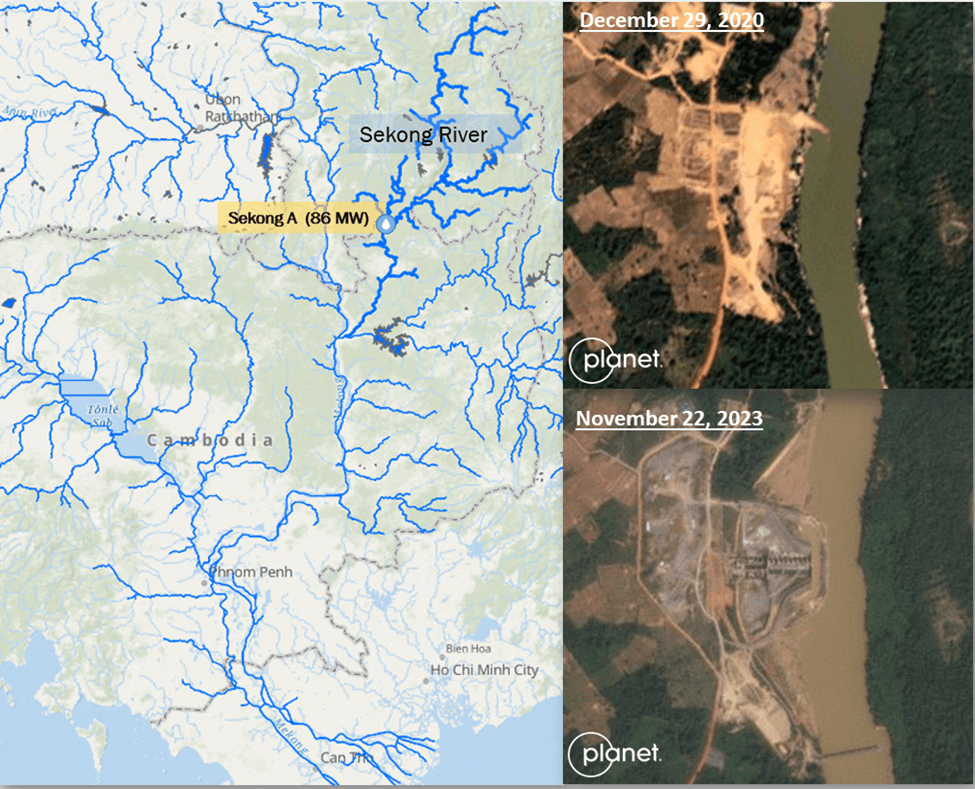
Location and Status of the Sekong A Dam
In June 2023, the MDM team published a comprehensive study on the impacts of more than forty dams in the transboundary 3S Basin of Vietnam, Laos, and Cambodia in and also included the near-real time monitoring of these dams in MDM weekly updates and analysis. The findings and ongoing monitoring have indirectly led to an agreement between Vietnam, Laos, and Cambodia to pilot official data sharing across borders and through the MRC, with the end goal of optimization of dam operation to balance hydropower production and reduce negative downstream impacts. If effective, this pilot project could lead to augmented data sharing across more MRC member countries and also identify pathways for data sharing and joint dam operations with China.
Effective Two-Way Conversation with Local Communities, NGOs, and Journalists
The MDM team relies on ongoing conversations with local community groups, NGOs, journalists, and academics to drive positive outcomes in the Mekong Basin. These Mekong Watchers often communicate what they see and hear to us, and we use satellite imagery to validate or at times invalidate their claims. This kind of call and response relationship with local stakeholders and users builds a momentum that demonstrates how transparency can improve accountability and how local stakeholders can contribute to an increasingly robust discourse of transboundary water diplomacy. The MDM provides a full picture of what is happening across the entire Mekong basin, and through its engagement with communities, NGOs, researchers, and journalists can feel in tune with the entirety of the Mekong. This has helped increase information availability on issues related to sandmining, health of flooded forests, fisheries depletion, and salinity intrusion, to name a few areas of concern.
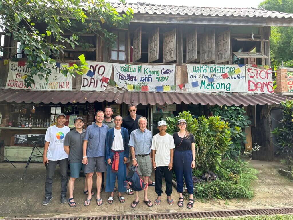
The MDM team meets with partners at the Mekong School in Chiang Khong, Thailand
MDM findings also identify issues for journalists on the ground to research. The MDM team has given more than forty media trainings since launch and partnered with organizations such as the Earth Journalism Network to train journalists to use the platform to inform their reporting. We have tracked a notable shift in how journalists use MDM information and data over time: at first journalists were mostly reliant on the MDM team to point out issues for them, but increasingly journalists can use the MDM platform as a research tool to identify issues without the need to engage the MDM team. Since launch, MDM data and information has been cited in more than 300 unique media articles ranging from local media outlets to major international outlets such as BBC News, NBC Nightly News, Reuters, and the Associated Press.
Early Warning Service
The MDM’s Early Warning Service to communities living along the Thai-Lao border is one of our most impactful services. As described in the best practices section above, the early warning service provides alerts when sudden releases or restrictions from China’s dams cause the river level to rise or fall over a half meter to provide local stakeholders time to respond and adapt. The early warning system protects the livelihoods of tens of thousands of people, has been incorporated into Thailand’s national disaster risk messaging system, Over the past three years, the number of early warnings issued has dropped significantly. In 2022 we issued 38 warnings, in 2023 we issued 16, and in 2024 to date we have only issued 8 early warnings. This suggests that China is now operating its dams with fewer sudden releases and restrictions of water – a positive outcome.
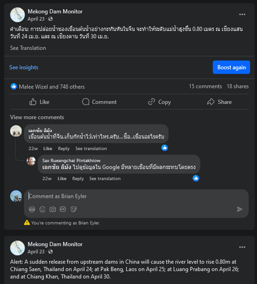
Example of an early warning alert published on Facebook in Thai and English (Lao language not shown).
When we started the early warning service in early 2021, there were very few successful global use cases of earth observation data to provide early warning to vulnerability communities. Nearly four years later, the use of earth observation for early warning is widely discussed at disaster risk reduction, anticipatory action, and climate resilience conferences worldwide. The MDM early warning service serves as an early mover in this space and has inspired our team to expand its early warning toolbox to the Himalayas with our Early Warning for Cascading Hazards in Nepal project.
What Work Remains to Be Done?
In the coming years, the MDM team will build on its achievements through localization efforts, adding new features and services to meet local needs, and plug our toolbox into new applications co-created and owned by local stakeholders.
While keeping in mind sensitivities to the official involvement of local partners and our commitment to doing no harm while working in a sensitive and complex political landscape, we plan to further localize our information products to appeal more directly to affected peoples and the public. Currently, our information products start in English language and are then translated into six national Mekong languages. These products are posted on a single Facebook page. We envision a transition to unique local language information products that are generated by local content creators based in the region and tied into the local challenges and needs. These local content creators would find meaningful information within each week’s data update and publish it on unique local language Facebook pages and, importantly, through other social media channels that are widely used in the region such as Telegram, Line, or WhatsApp. Local content creators could also be more active in communicating with social media users through comments and conversations in local language, and the lessons learned from this communication could identify new issues, hotspots, or affected community groups to watch with MDM service coverage.
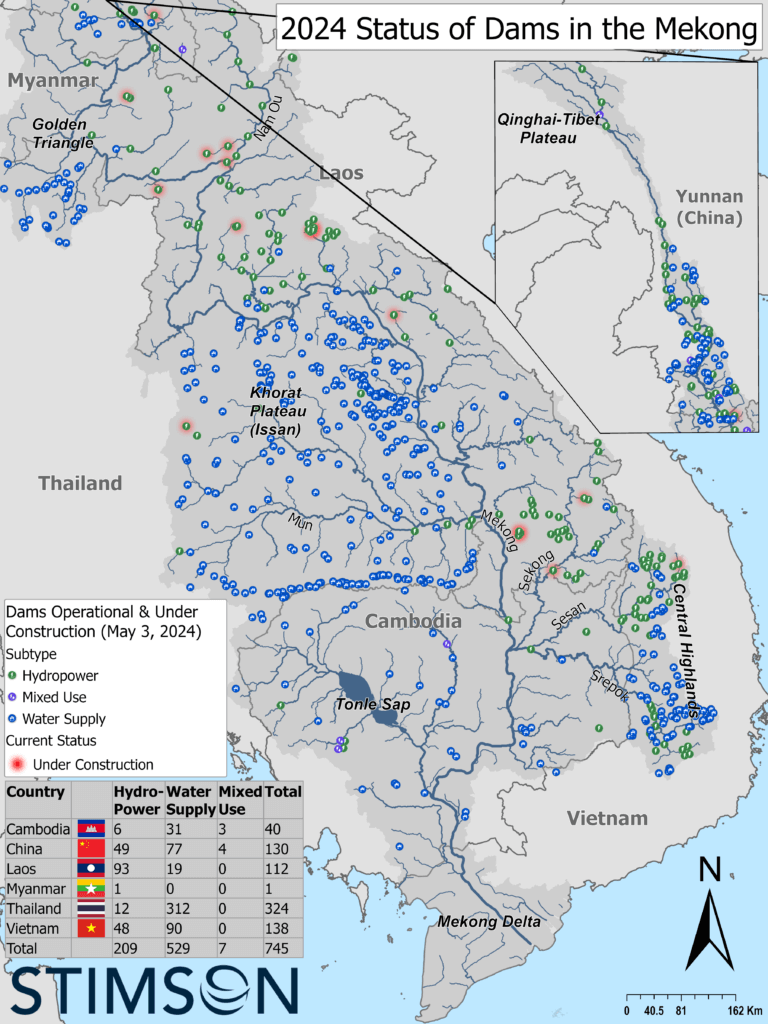
With more resources and effective localization, the MDM can monitor much more of the Mekong and provide a more comprehensive and accurate analysis of the impact of dams, climate, and other human activities to the Mekong’s natural hydrological cycle. The team has tracked the development of more than 600 operational dams throughout the six countries of the Mekong Basin, but we currently only monitor the 60 largest dams. While there is little need to monitor all 600 dams since most have very small reservoirs, a preliminary scope suggests that new reservoirs currently not monitored in Laos could alone account for an additional 10-15 billion cubic meters of active storage on top of the 50 billion cubic meters of active storage already monitored by the MDM. This suggests that our efforts are missing ~15-20% of actual storage capacity in the Mekong Basin, and as such we are underestimating the impacts of how all dams in the basin impact flow to key ecological features like the Mekong floodpulse and the Tonle Sap Lake. With more research partners monitoring these dams, we can provide a fuller picture of dam impacts. The same can be said with extending our natural flow models downstream all the way to the Mekong Delta.
With the right effort and right research partners, much more work can be done to monitor dam impacts to the lower Mekong floodplain and the Mekong Delta. People living in Cambodia and Vietnam feel the acute effects of sediment and sand being removed from the river system by sandmining and entrapment behind upstream dams. Sediment and sand removal is resulting in a significant rise in riverbank collapses. Studies also show how this activity is lowering the bed of the river throughout the Mekong, thus making it harder for natural wet season inundation to saturate wetlands and generate healthy ecosystems. In the Mekong Delta, lower riverbeds are inviting increased salinity intrusion further inland, negatively affecting industrial and small-scale agricultural practices. Earth observation techniques can be used to monitor the river for sediment loss and sandmining and lead to improved regulations that mitigate the impacts mentioned above.
Finally, in the sections above, we have discussed the limitations of the MDM, outside of our early warning service, to reach local fishers and farmers as a decision support tool to improve their resilience. With further localization, our efforts could begin to speak to local communities in a language that they better understand—but to achieve meaningful change at the community level, we look forward to building new partnerships with local organizations to co-create hyper-localized smartphone applications curated to speak to local fishers and farmers. While these hyper-localized applications would bring in and utilize transboundary data such as upstream dam impacts and forecasting, their coverage area would encompass a national or sub-national scale and target local needs. The applications would be co-designed through participatory and iterative processes with local community stakeholders and government actors, where applicable, and include data inputs from local communities and government actors. Such applications could include wetlands monitoring and flash flood early warning applications for Chiang Rai and Phayao Province in Thailand’s portion of the Golden Triangle; an adaptive fisheries management application for the Tonle Sap Basin to guide fishing practices and conserve fish population health; and a water quality and water availability application for farmers in Vietnam’s Mekong Delta that provides modeled and accurate forecasting for thousands of kilometers of irrigation canals throughout the delta.
We look forward to working with new partners to identify new resources and institutional arrangements that can achieve greater resilience for local communities and improve transboundary water governance in the Mekong in the years to come.