
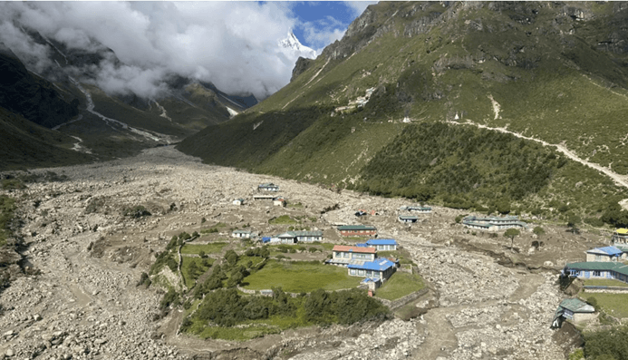
Header image: Thame village in Khumbu Pasang Lhamu rural municipality of Nepal’s Solukhumbu district after the Aug 16th GLOF (Image: Laxman Adhikari)
On August 16, a glacial lake outburst flood (GLOF) devastated the village of Thame – a Sherpa settlement located at 3800 meters elevation in Nepal’s Solukhumbu district, commonly referred to as the Everest region. The torrent flowed right through the heart of Thame, destroying twenty-five homes and guesthouses, a school, a health post, a local hydropower project, and a major bridge downstream. The disaster displaced 135 people in total and generated significant anxiety for Sherpa communities throughout the region, particularly those living in the shadow of other glacial lakes, such as Imja Tsho and Tsho Rolpa. By highlighting the unjust intensification of climate-related risks that Himalayan communities are being forced to cope with, this disaster also sparked global conversations about climate justice. Tenzing Chogyal Sherpa, a cryosphere scientist who hails from the region, described it this way: “Seeing the ancestral homes of Sherpa families in ruins was devastating… This starkly highlights how vulnerable our mountain communities are and underscores that climate change impacts are not a distant concern—they are happening now, right in our backyard
Understanding the Hazard Chain that Shaped the Thame GLOF Disaster
In the hours and days that followed, scientists from Nepal and around the world sought to investigate and understand the causes and processes that shaped this tragic event. Our team at Stimson also contributed to this process, working remotely to examine satellite imagery, interpret photographic evidence, and share our analysis with government authorities like the Department of Hydrology & Meteorology (DHM). These analyses complemented field-based work by the National Disaster Risk Reduction & Management Authority (NDRRMA) of Nepal, which worked with local government officials to carry out disaster response activities and conduct preliminary field-based assessments. Over the course of a few days, the dimensions of the disaster gradually came into focus.
The GLOF originated from two relatively small glacial lakes located about 10km upstream of Thame referred to as Upper and Lower Tso Mutse – part of a cluster of five lakes situated at an elevation of 4750 meters, sometimes referred to as the Thyanbo lakes. Evidence gathered suggests that the hazard chain was initiated by a minor slope failure from the glaciated area immediately upslope from Upper Mukse (likely either ice, rockfall, a small avalanche, or other debris) potentially triggered by rapid warming in recent days. This seems to have triggered a surface wave that overtopped the moraine at the lake’s outlet, releasing a burst of water that flowed into the larger lake below – evidenced by scouring along the flowpath between lakes (see our annotated satellite image below). This surge of water into the lower lake, caused a catastrophic failure of the moraine dam that limned in Lower Mukse, causing a GLOF which released 88% of the water in the lower lake. The flood pulse carved down through the river channel eroding the banks, picking up debris and boulders the size of cars, flowing into Thame and beyond. High flow conditions were apparent for several hours at DHM-owned river gauging stations in the Dudhkoshi River, even 85km downstream.

Image showing the Upper Tso Mutse and scarring beneath its outflow – a still extracted from a video captured by a reconnaissance helicopter flown in the wake of the event by local authorities. (Video shared publicly by Khumbu Pasang Lhamu Rural Municipality)
By interpreting satellite imagery from public and private providers (our team also tasked an Umbra satellite to capture targeted images) the Stimson team was able to provide timely analysis and information to the Government of Nepal’s Department of Hydrology and Meteorology, which was featured in their official report on the Thame GLOF (our team’s unofficial English translation of the DHM report here). We also created annotated information products which we shared on social media platforms, posting in both English and Nepali to help communicate these findings to a broader public audience.

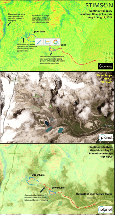
Two sets of annotated satellite images created by the Stimson EWS Team in the wake of the Thame Disaster and publicly shared on social media. The first set of images shows scouring between the lakes, highlighting the cascading flow between lakes – using both PlanetScope optical imagery and high-resolution SAR imagery from Umbra. The second uses Sentinel-1 SAR data to analyze lake levels and landform changes in the surrounding area, showing loss of lake volume and potential mass loss in the glacier just above the upper lake. More detailed captions and a Nepali language version is available @ForeCNepal on X (Images: The Stimson Center).
In the wake of this event, both Sherpa community members and cryosphere experts have highlighted the need for a paradigm shift in cryosphere risk assessment practices to better accounts for shifting cryosphere conditions and potential human impacts. As community leader Ang Tshering Sherpa recently told the BBC: “[These lakes] were the smallest ones and no one cared about them, and yet the damages have been so huge. Imagine what could happen if the big ones burst out. There are many of them in the Everest region.”
While three of the Thyanbo lakes had been included in regional glacial lake inventories, the group was generally classified as relatively low risk and therefore not actively monitored. The other two lakes, including Upper Mukse, were not accounted for or fully evaluated due to their smaller size – though they had gained volume in recent years. Other infamously risky glacial lakes in neighboring valleys like Imja Tsho or Tsho Rolpa have long been the subject of intensive research and monitoring and sites for flagship GLOF-risk management projects. Unfortunately, the Tso Mutse lakes were in something like a scientific blind spot.
GLOF Risk in the Himalayan Context & The Dig Tsho GLOF of 1985
Glacial lakes and glacial lake outburst floods, or GLOFs, are an inevitable product of Himalayan glaciological and fluvial geomorphological processes. Recent studies by a team from the International Centre for Integrated Mountain Development (ICIMOD) has yielded a comprehensive inventory of glacial lakes – over 25,000 identified across the Hindu Kush Himalayan region, with 47 glacial lakes classified as highly dangerous. To date, geoscientists have identified evidence of 26 past GLOF events in Nepal alone, though many other smaller events in remote areas are unrecognized and unaccounted for. In recent years, exposure to these natural hazards has increased due to anthropogenic climate change that causes glaciers to lose mass, existing lakes to swell, and new lakes to form and grow.
Some of the high-risk glacial lakes that scientists and state authorities are most worried about are in watersheds very close to Thame. This includes Imja Tsho, a lake closer to Mt. Everest (Sagarmatha) above Dingboche, and Tsho Rolpa, the largest glacial lake in Nepal which is only 10 kilometers away from the Thyanbo lakes, just over the ridgeline in the Rolwaling Valley. Both Tsho Rolpa and Imja Tsho were the targets of multimillion-dollar “lake-lowering” risk mitigation programs carried out by UNDP in partnership with the Government of Nepal, in 2000 and 2016, respectively. These efforts, combined with in situ instrumentation that monitors lake conditions represent an investment in climate adaptation and early warning systems. The system installed at Tsho Rolpa, for example, includes instrumentation that can generate SMS alerts to downstream communities. The shift to “digital sirens” that replace older physical siren relay systems hints at the multidecadal cum intergenerational nature of these risks.
Given the technical challenges of monitoring all lakes and constraints on resources, some lakes are deemed high-risk and get more attention and investment in monitoring efforts than others – a form of climate risk triage. As such, the Tso Mutse lakes were not categorized as high priority.
However, the village of Thame has been hit by a deadly GLOF once before: from a different glacial lake called Dig Tsho, located just one drainage north of the Thyanbo lake cluster. The Dig Tsho Disaster occurred in August 1985 when an ice avalanche from the Langmoche glacier fell into the lake, creating a wave that overtopped and then cut through the moraine dam holding the lake back. This unleashed a flood of 5 million cubic meters over a period of 4-5 hours, killing at least five people, washing away 15 bridges, and destroying the first-generation hydropower plant in Thame. Then, as now, Himalayan hydropower projects and other in-stream infrastructures, small or large, are vulnerable to cryosphere hazards.

To create a sense of the magnitude of the 1985 Dig Tsho GLOF, scientists created a to-scale image of the U.S. Statue of Liberty situated in the gap the flood created in the lake’s moraine dam. (Image: D. Vuichard 1985)

Floodwaters of the 1985 Dig Tsho GLOF surging past the Namche Small Hydel Plant. (Image: G. B. Shrestha August 4, 1985).
Ironically, the Dig Tsho GLOF was an early example and warning of the kind of cryosphere disasters that climate change impacts on the Himalayan cryosphere might bring – drawing scientific and policy attention to the issue. Experts and locals have monitored this lake ever since the disaster, and while overall lake volume and GLOF risk were reduced by the 1985 event, the lake continues to expand and contract as climate change destabilizes the surrounding landscape and glaciers melt.
Climate Change & Increasing GLOF Risk
With the Thame GLOF, all signs indicate that this multi-hazard chain was also shaped by increasing climatic volatility and recent warming trends. (See the 2019 HKH Assessment or the 2023 HI-WISE Report for more information and context on the broader impacts of climate change in the mountain cryosphere across the Himalayan region). Glacial loss increases glacial lake volumes and warming temperatures weaken high-altitude permafrost, destabilizing slopes and moraines that could send material into the lake, triggering such a cascading event. Some GLOFs have also been triggered by extreme precipitation events and increased monsoonal volatility. According to locals, the Upper Mukse lake only began to emerge in recent years, as the glacier retreated – one reason it was not recognized as high risk in existing glacial lake inventories. At the time of the event, both lakes were brimming with glacial meltwater in the wake of an extended warm spell. The Government of Nepal’s Department of Hydrology and Meteorology reported that temperatures had been rising in Solukhumbu since August 9 and peaked around 15 °C on the day of the disaster.
As climate change continues to destabilize the high Himalayan region, the Thame Disaster also raises timely questions about how we prioritize some cryosphere risks and at-risk areas over others. The Tso Mutse GLOF demonstrates the potential destructive force that even a relatively small glacial lake can unleash, with the risk of cascading and compounding hazard chains amplified by increasingly volatile climatic conditions.
Anil Pokhrel, the Chief Executive of Nepal’s National Disaster Risk Reduction and Management Authority (NDRRMA), recently described the problem to me this way: “To date, these lakes have been prioritized by hazards, and not by risks. The size of a lake is just one among many other critical factors, but this is insufficient by itself [to guide decision-making]. We need people-centered perspectives that account for human vulnerability and risk downstream.” Shifting from a hazard-centered model of assessment to a risk-centered model that accounts more fully for potential human impacts and economic loss and damage requires gathering better data on exposure and its vulnerability in downstream areas.
Generally speaking, glacial lakes are known unknowns. While the scale and timing of any given GLOF is highly uncertain, the lakes themselves are identifiable, locatable, enumerable, and largely observable (using both in situ and remote sensing technologies). The scientific challenge is to think about potential contingencies and processes – to map out the ways these lakes might interact with other landforms within a melting Himalayan cryosphere, and to model different breach scenarios and runout distances. Scientists have developed a variety of techniques to assess GLOF-related risks and to model different outcomes. But even for infamous high-risk lakes, it is extremely difficult to monitor conditions in real-time or generate effective warnings for downstream populations.
For example, in October 2023, a gradually weakening moraine collapsed into Sikkim’s South Lhonak Lake, causing a GLOF that caused billions of dollars in damage and killed 102 people (if interested, see also this Stimson webinar for more information on this event). Unfortunately, the early warning system that had been recently built at the lake was not functioning at the time of the disaster due to technical glitches with instrumentation – a fact that highlighted the value of earth observation tools for both monitoring and rapid assessment. Perhaps unsurprisingly, in Sikkim as with the 2021 extreme flow events in Nepal’s Melamchi basin, phone calls between villages (enhanced by expanding networks in Himalayan terrain) have proven to be an appropriate technology – pointing to the value of complementary or redundant technologies, and the critical role of local communities.
Talking about Thame at World Water Week
The Thame Disaster was also a recurring topic of conversation at the recent World Water Week in Stockholm (Aug 25-29). Leadership from ICIMOD in Kathmandu, Director General Pema Gyamtsho and Dr. Arun Bhakta Shrestha, highlighted the event as both an example of clear and present Himalayan climate risks and evidence that more comprehensive risk assessment methods are needed. Colleagues from the Asian Development Bank located the Thame Disaster within a stream of climate-related disasters that have damaged critical infrastructure across the Himalayas and Hindu Kush in recent years – listing the 2021 Chamoli avalanche in India; the 2021 Melamchi debris flow in Nepal; extreme flooding in Pakistan in 2022 and 2023; the 2023 Uttarakhand floods and South Lhonak GLOF in India, and recent floods in Afghanistan in 2024 together in a single and terrifying slide.
Professor Pasang Yangjee Sherpa from the University of British Columbia also stressed the existential risks at stake and argued for the ethical and practical importance of recognizing local expertise and the agency of Sherpa communities. Speaking on a panel focused on transboundary cryosphere risks and the critical role of “glacier guardians”, Pasang pointed out the fact that Thame locals knew the Tso Mutse lakes had grown in recent years and described the ways that locals used satellite images in the wake of the disaster to inform decision-making processes. Wary of past studies that have marginalized local expertise and knowledge holders in the Solukhumbu, she also called for locally-led processes of recovery and hazard assessment in Thame.

A session focused on Himalayan cryosphere risks and ‘glacier guardians’ at Stockholm World Water Week 2024, including speakers (left to right): Ms. Shuchi Vora (Global Resilience Partnership), Austin Lord (self), Dr. Arun Bhakta Shreshta (ICIMOD), Dr. Pasang Yangjee Sherpa (University of British Columbia), and Alok Sikka (International Water Management Institute). Session organized by IWMI & the U.S. Department of State. (Image: Brian Eyler)
In my own comments on the “glacier guardians” panel, this author highlighted the value of bringing together localized monitoring efforts with satellite observation to build more comprehensive and nuanced monitoring programs and early warning systems. Amid the race to build new high-tech monitoring systems that leverage evolving remote sensing tools and capabilities, earth observation technologies, and AI, we also need to better account for situated knowledge—both the kind that comes from long-term place-based observation by people attuned to subtle changes in the landscape and newer collaborative efforts we might refer to as ‘citizen science.’
The Value of Localized Data & Monitoring
As argued in a related op-ed for Dialogue Earth earlier this year, this kind of pluralistic and integrative approach can help identify potential hazards (read: knowing where to look), and also enhance two-way dialogue that increases the efficacy of early warning systems and early action plans. Greater attention to cultivating localized monitoring efforts and recognizing local perspectives can also help analysts and policymakers pivot to the risk-centered model that Anil Pokhrel suggested is needed, which requires place-based understandings of exposure and the social context that shapes vulnerability.
Tellingly, the first people to flag increasing risks at Dig Tsho prior to the 1985 GLOF were also herders from the Thame Valley who abandoned their summer camp after witnessing small avalanches into the lake creating minor overtopping waves (see Vuichard & Zimmerman 1987). Across the Himalayan region, researchers have been using oral histories, participatory mapping, and other community-engaged methods to identify and reconstruct past disasters that were previously unrecognized or to improve practices of post-disaster loss and damage assessment.
The Langtang Valley, for example, has been a hotspot for research on glaciers and climate change impacts for more than fifteen years. On April 25, 2015, the Gorkha Earthquake triggered a massive co-seismic avalanche that completely destroyed the village of Langtang and killed nearly 300 people. As both a survivor of this event and a social scientist, I’ve had countless conversations with Langtang residents about glacial hazards, risk reduction strategies, and the impacts of climate change over the years. Elders and herders in particular have described past events and risks that scientific research in the area had not detected.It is heartening to see pieces like a recent Nature article published earlier this month, which argues that the 2015 Langtang avalanche was shaped by climatic volatility that created unseasonal snowpack and unstable cryosphere conditions. Still, Langtangpas made these connections long ago.
Tellingly, none of the scientific teams working in Langtang at the time of the 2015 avalanche disaster were monitoring cryosphere hazards or watching the glacier and avalanche chute directly above Langtang village. In Langtang, as in Thame, a deadly cryosphere disaster blindsided authorities and experts, even as scientists examined other cryosphere problems nearby.
And that brings us back to the lesson that emerges from the Thame Disaster: as the landscape of Himalayan hazards continues to shift in the face of climate change, we need to utilize multiple methodologies to a) determine where to focus analytical attention and interventions, b) recognize different kinds of knowledge and expertise that can help with risk management and adaptation, and c) identify new unknowns, sources of uncertainty, and blind spots.
Rethinking the Rules of Triage for Climate-Related Cryosphere Risks
Just a few days ago, Professor Wilfred Haeberli from the University of Zurich and Dr. Alton Byers from the University of Colorado, wrote a piece in the Nepali Times that suggested there is a need to “update and revise the current list of potentially dangerous glacial lakes in Nepal” to include even relatively small lakes (like Upper Tso Mutse) which could pose downstream risks under the right conditions. The authors also pointed out a need to harmonize or standardize glacial lake risk assessment methods, enabling greater consensus and limiting confusion. I agree, and information management undertakings like this GLOF dashboard created by a team from ICIMOD are a move in that direction. At the same time, while standardized methodologies and metrics are necessary, it is also critical to ensure that these standards do not overlook the nuanced human context and factors that shape impact and vulnerability. So, how should we do that?
Given the limited resources available to face the Himalayan climate crisis, and the challenge of surveying a shifting landscape where thousands of potential hazard chains are possible, hazard monitoring does become a question of triage. At one level, the concept of triage is an easy metaphor to describe the challenge at hand – with triage understood as a process or set of parameters developed to navigate uncertainty and allocate limited resources amid a crisis. But, at another level, triage is also an apt term for the material challenges that policymakers, climate scientists, and people living on the frontlines of climate change face as they struggle to respond to the unevenness and unpredictability of climate-driven disasters and real human suffering.
As events like the Thame GLOF become more frequent in our current historical moment, in the Himalayan region and elsewhere, we need to rethink the ways we come up with the rules and standards that guide our attempts to navigate the climate crisis. Critically, the concept of triage is not universal or truly objective – systems of triage are socially and technically determined, calibrated to reflect values and ethical assumptions, and can be modified or modulated in light of specific scenarios and issues. To be clear, this is not a normative recommendation for a specific set of rules; or a system of triage that subordinates or abandons the most challenging cases in order to reallocate resources to other problems that seem solvable. (That would be one mode of triage, and similar debates are already playing out in the context of decision-making over strategic or managed retreat and the anticipatory politics of loss and damage – but this is not an argument for such an approach). This point is to highlight the fact that events like Thame can and should force us to rethink the systems of triage that seem to be implicit in our current systems of disaster and climate risk management and that this will likely require both changes in methods of evaluation and changes in values.
In the current moment, however, it does seem clear that we need to recalibrate our systems of triage to reckon with issues of climate injustice. This would mean reconfiguring existing processes for risk assessment and determining adaptation priorities – for example, facilitating policy-oriented dialogue in ways that meaningfully recognize a greater diversity of voices or reorganizing data collection in ways that account for alternative sources of data. As the Thame Disaster, the Langtang Disaster, and other events indicate – updating the rules of Himalayan climate triage and improving the efficacy of monitoring systems may not be so much a matter of making new data as recognizing and translating other forms of existing data that are currently overlooked.
In any case, the arts of triage require both adaptive management and a near-constant reckoning with uncertainty – and these are the skills that Himalayan risk managers, working at all scales, need to cultivate in the context of the climate crisis.
Looking Ahead from Thame
As government, civil society, and science partners work together to build new systems that attempt to extend the UN promise of Early Warnings for All across the Himalayan region, we must invest in climate adaptation efforts that support and include mountain communities. This work begins with and requires an epistemic reorientation that makes space to reevaluate the ways we reckon with shifting and competing cryosphere risks: by reimagining what kinds of problems and data count. Building comprehensive multi-hazard monitoring programs and research programs that meaningfully incorporate local knowledge and local experts within risk analysis and decision-making processes is not just a matter of humanitarian, economic, or scientific concern; it is a matter of climate justice.
One month after the Thame Disaster, government authorities and scientists are still at work assessing extant risks and formulating plans for recovery and reconstruction, a process which must include resettlement and the assessment of potential future hazards. Community members in Solukhumbu remain shocked and unsure of what they can expect from a climate-impacted future. Scientists and activists alike are trying to foreground the Thame disaster to ensure that such events are factored into revised models of multi-hazard risk assessment and ongoing negotiations about climate adaptation policy and Loss and Damage. As the aftermath of this disaster continues to unfold, many different people are contemplating the cascading uncertainties that surround events like the Thame GLOF, and some are reevaluating the approach we have used to assess and prepare for Himalayan cryosphere risks to date.
In response to the Thame Disaster and in anticipation of future climate-related disasters, we need to rethink both the ways we examine potential interactions between cascading Himalayan hazards and the ways we reckon with the human factors that shape downstream risk. We also need to prioritize applied climate research that seeks to reckon with immediate climate injustices and adaptation needs. Making progress on these fronts will undoubtedly require improvements in the science and technology of multi-hazard risk assessment, but it will also include reflection on the epistemic assumptions and ethical positions that shape collective judgment about whose problems, priorities, and uncertainties matter most.
About the Author
Austin Lord, Ph.D. is a Senior Fellow in the Energy, Water, & Sustainability Program at the Stimson Center. He is an environmental anthropologist and disaster risk practitioner with over 12 years of experience in the Himalayan region, and he leads the Early Warning Systems for Cascading Hazards in Nepal project which the Stimson team has been working on since 2022.


Current Geopolitics Shift Deep-Sea Mining Debates