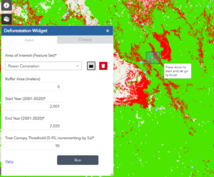
The Mekong Deforestation App is a mapping and reporting tool that tracks forest loss in the Mekong region with focus on forest loss in relation to infrastructure projects catalogued in the Mekong Infrastructure Tracker’s infrastructure geodatabase. For example, users can select a hydropower plant’s reservoir and summarize its surroundings (in hectare) for forest loss and intact forest as far back as 2001. The App’s data is derived from the publicly available Global Forest Change dataset- a collaboration between the Global Land Analysis & Discover Lab at the University of Maryland, Google, USGS, and NASA- and has been cleaned and processed for the Mekong Deforestation App. Through this tool, the Stimson Center hopes to widen accessibility to GIS research methods and data transparency, provide robust analysis to strengthen ESG standards, and mitigate further risks from project developments.