
This risk profile was produced in collaboration with the Ocean Policy Research Institute of the Sasakawa Peace Foundation and Ecosensya Solutions for Environmental Sustainability. We also wish to extend special thanks to the Ocean Policy Research Institute-Sasakawa Peace Foundation and the Nippon Foundation for its generous financial support to the Climate and Ocean Risk Vulnerability Index (CORVI) project.
Dagupan
Dagupan City, located in the Province of Pangasinan in the Ilocos region of Luzon Island, is a coastal city with a large aquaculture industry. As the national top producer of milkfish (bangus), it is known as the Bangus Capital of the Philippines. It has 171,271 inhabitants, and its population is expected to increase by 7.18 percent in 2023.1 Note: Philippine Statistics Authority, “2015 Census of Population, Report No. 2 – Demographic and Socioeconomic Characteristics Pangasinan,” (June 2017), accessed March 14, 2022, https://psa.gov.ph/sites/default/files/01_Pangasinan.pdf. The city has a geographic land area of 40 square kilometers and is politically divided into 31 barangays or barrios. It is bounded by Lingayen Gulf in the north and has an expansive network of seven rivers, making up 14 percent of its total land area.2 Note: City of Dagupan, “Physical Profile,” accessed March 14, 2022, https://www.dagupan.gov.ph/our-city/physical-profile/.
Empirical data from 73 expert surveys is incorporated into the CORVI risk profile of Dagupan and displayed across 10 risk categories and 94 indicators. These risk scores are supplemented with information from 20 interviews with subject matter experts for the different categories. In some cases, risk scores may conflict with information given in the subject matter expert interviews; such instances are noted in the text.
Summary Findings
The City of Dagupan is undergoing an economic renaissance; it is experiencing dynamic economic growth, particularly in the service industry; and it holds a position as the nucleus of a larger economic zone that includes many towns in the Pangasinan Province. It is the regional center for commerce, education, and health services, with hospitals, universities, and a cross-sector of businesses and culture. The city government’s operational budget has increased, showing strength in its ability to provide services to residents. The fast-growing service economy is bringing benefits to the people of Dagupan City. However, to ensure continued economic health and the safety of Dagupan’s residents in the face of climate change, it is important to understand key climate vulnerabilities and build resilience where it matters most. This report describes climate vulnerabilities in the Dagupan metro area and makes recommendations designed to help provide a pathway that balances economic growth in the service economy with a sustainable blue economy that relies on healthy natural resources and benefits all citizens of Dagupan.
The CORVI risk analysis for Dagupan City highlights a vulnerable coastal and marine ecosystem, with Climate (7.56) and Geology/Water (7.13) having the highest risk scores overall. Following this is the successive ranking of Economics (6.63), Infrastructure (6.33), and Major Industries (6.04) at medium-high risks, emphasizing the risk to the local economy, housing, employment, and infrastructure from extreme climate events. Among the political risks, Stability (5.51) ranks highest due to strong dependence on climate-vulnerable industries and highly vulnerable populations.
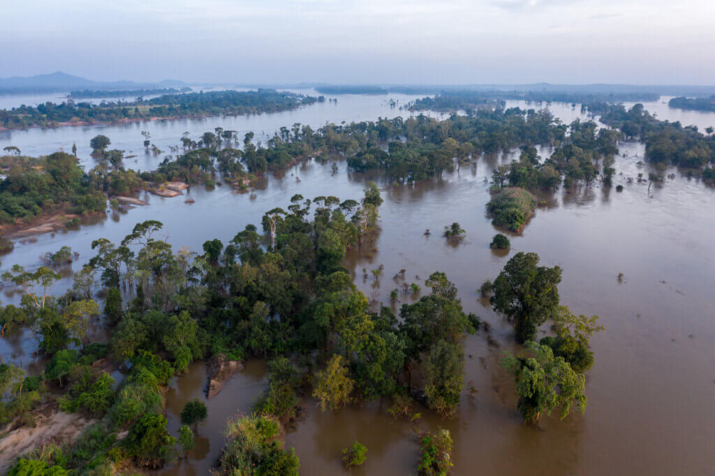
Historic perennial flooding and evolving threats to water security are the two main ecological problems Dagupan City faces. The climate risk assessment identified such problems as symptoms of geophysical and climate events that are intensified by human activities. Even without climate change, Dagupan is predisposed to high risks of flooding and liquefaction because of its low topography, location on a river delta, and the extensive seven-river system.3 Note: Interviews with representatives from Central Visayan Institute Foundation, September 2021 and from the UP National Hydraulic Research Center, October 2021. The city was built over the lower reaches of the Pantal River, which has an intricate, meandering pattern. Over time, the course of the river has naturally shifted, leaving an abandoned portion of the river channel, created by sediment transport during previous floods and inundation. As a result, loose deposits of silts and sands now comprise areas of the old river channels. This makes Dagupan highly susceptible to liquefaction if an earthquake occurs, such as during the 1990 Luzon earthquake that severely damaged the city.4 Note: Kenji Ishihara, Alex A. Acacio, and Ikuo Towhata, “Liquefaction-Induced Ground Damage in Dagupan in the July 16, 1990 Luzon Earthquake,” Soils and Foundations Vol. 33 No. 1, 133-154 (March 1993), accessed November 5, 2022, https://www.jstage.jst.go.jp/article/sandf1972/33/1/33_1_133/_pdf/-char/en In addition, the city serves as a catch basin for three river tributaries from neighboring cities.5 Note: Zenon Richard P. Mateo and Fernando P. Siringan, “Tectonic Control of High-Frequency Holocene Delta Switching and Fluvial Migration in Lingayen Gulf Bayhead, Northwestern Philippines,” Journal of Coastal Research no. 231 (January 2007): 182, accessed March 14, 2022, https://dx.doi.org/10.2112/04-0152.1 Though Dagupan has an excess of floodwaters, it is starting to experience a decline in its drinking water supply and faces other freshwater concerns. Changes in climate patterns have led to extreme weather events, including typhoons and sea temperature rise, which have recently caused rice crops to die off, diminished the yield of locally grown water spinach (kang kong), and resulted in the drying of artesian wells. These indicators suggest saltwater intrusion and reduced groundwater supply.6 Note: Comments of Ronald De Guzman from City Disaster Risk Reduction and Management Office, February 2022
Limited industrial waste treatment infrastructure and inadequate residential sanitation services, along with illegal mangrove cutting for boatmaking, housing, and charcoal, have undermined the health of the coastal, marine, and riverine environment and the health of citizens. With no sewage treatment facility or sanitary landfill yet in place, debris and water pollution from informal river dumping of household waste and from the fishing industry pose risks to human health and the economy, via clogged canals, increased flooding, land subsidence, and the contamination of milkfish (bangus). Moreover, the loss of mangroves degrades marine habitat important to nearshore fish stocks, which are in decline due to overfishing, overstocking, a proliferation of illegal fish pens/cages, and urban water pollution. The Bureau of Fisheries and Aquatic Resources (BFAR) has observed noticeable declines in size, weight, and quantity of nearshore fish stocks. This trend has direct implications for the overall value chain connected to Dagupan’s fishing and aquaculture industry, affecting not only fishing activities, but also related businesses such as fish processing, fish pens, cages, processing facilities, and wet markets — and the people these businesses employ. The decline in fish production may also have downstream effects on other associated industries such as those in the tourism and service sectors (e.g., restaurants, malls, hotels).
National efforts geared towards resilience-building include the establishment of the Philippines’ two main frameworks on climate change, the Climate Change Act of 2009 (Republic Act (RA) No. 10174) and the Philippine Disaster Risk Reduction and Management Act of 2010 (RA No. 10121), which provide public accessibility to long-term funding of climate change projects and the fundamentals in building disaster-resilient communities, respectively.
The Dagupan local government unit (LGU) released their Flood Mitigation Report of 2019, a 10-year master plan designed to address the perennial flooding of the city. The report’s recommendations include conducting a city topographic survey; building gray infrastructure such as dikes, floodgates, and pumping stations; dredging shallow rivers; and creating legislative policies for proper solid waste management and transformation of rivers and creeks into tourist hubs.7 Note: City Government of Dagupan, Flood Mitigation Commission, “The Flood Mitigation Commission Report,” Joseph Lo et al., (Dagupan City, 2019), page # 8-10. In addition, the Task Force Bantay Ilog of the Dagupan City Government has been monitoring and removing illegal fish pens along the waterway. Other government efforts also underway include developing a zero-emissions waste-to-energy plant that will convert plastic trash into diesel to power public utility vehicles and fishing boats, cleaning canals and coastal areas from clogged garbage, replanting mangroves in areas of bald patches, and planting natural seawalls along shorelines to serve as barriers against coastal erosion.
This CORVI risk profile identifies three priority areas in need of action to build resilience in Dagupan City and plan for systematic risks:
Summary Recommendations
Institutionalize Climate Resiliency Project Planning and Implementation to Reduce Flood Risks, Sustain Economic Growth, and Improve Human Health and Safety
Recognizing the extended time horizon for climate risk-related infrastructure project planning and implementation, the Office of the Mayor and the Dagupan City Council should work together to pass laws, ordinances, and multiyear planning budgets that codify and institutionalize sustainable infrastructure and renewable energy projects into law. Infrastructure projects and ordinances, both nature-based and constructed, could include implementing flood mitigation measures, circular economy initiatives such as the SURE Global Waste to Worth Innovations (W2WI) waste-to-energy project, solid waste management, wastewater treatment infrastructure, replanting mangroves, renewable energy development, and instituting green building codes.
Implement Decentralized Nature-based Solutions for Wastewater Treatment and Groundwater Recharging in Vulnerable Communities
Efforts to improve water quality and supplies of clean drinking water are needed to reduce climate-related risks to vulnerable populations and key industries. Decentralized nature-based solutions for wastewater treatment should be used to fill gaps in local barangays prior to the rollout of the sewage treatment plant. Dagupan City should also develop and implement plans to address their waning groundwater supply. Increased urbanization, population density, and shoreline development has increased the extraction of groundwater, and the drying of artesian wells, as sea level rise further threatens saltwater intrusion into existing groundwater supplies. Nature-based solutions offer an inexpensive and efficient way to recharge local aquifers by using natural materials at a decentralized scale. The city should prioritize implementing local nature-based solutions in barangays that are the most at risk, including those communities that cannot afford to connect to the water district. In addition, the City Planning and Development Office, City Disaster Risk Reduction and Management Office, and local barangay captains should work together to reach the goal of zero defecation in open areas by providing sanitary toilets and by educating residents on safe and healthy sanitation practices.
Improve the Sustainability and Diversity of the City’s Blue Economy Industries
Improving the sustainability of the city’s blue economy industries (e.g., aquaculture, fisheries, and tourism) is key to ensuring climate resilience. The LGU, City Agriculture Office, and Bureau of Fisheries and Aquatic Resources have been educating locals on sustainable fishing, replanting mangroves, enforcing strict measures against overfishing and overstocking, implementing physical distances between fish pens/cages, and eradicating illegal fish pens to prevent fish kills. They should continue to improve and implement these measures. In addition, Dagupan should seek to diversify its coastal tourism industry beyond activities related to bangus. For example, opportunities may exist to develop sustainable tourism, and ecotourism businesses along the beachfront on the Lingayen Gulf.
With these measures, Dagupan can continue to grow the economy, improve the health and safety of its people, and strengthen its resilience against the impacts of climate change.

Ecological Risk
The two highest-scoring risk categories in the Dagupan CORVI risk profile are Climate Change (high risk) and Geology and Water (medium-high risk). These ecological risks suggest that Dagupan is vulnerable to threats of flooding from tropical storms, and vulnerable to water security issues because of inherent features of its surrounding climate and geological makeup. The City of Dagupan is at the confluence of seven rivers, and twice as many creeks, its low elevation making it particularly vulnerable to flooding. Yet these geological factors also add significant value to the city’s blue economy, providing nursery habitat for nearshore fisheries and local conditions conducive for aquaculture, primarily pond-raised bangus for which Dagupan is best known. With two of the highest category scores in the CORVI risk profile related to climate and geology, vulnerabilities to flooding, typhoons, sea-level rise, and coastal erosion are likely to impact the city’s population and economy.
- The category of highest risk overall is CLIMATE (expert weighted average 7.56), due to high risk scores in the frequency of rainfall-induced floods (9.16), total number of wet days (8.85), and total number of tropical cyclones (8.09). Though the total number of dry days (7.19) is a medium-high risk, experts interviewed predict an increase in drought events as a result of prolonged monsoon breaks.
- Following this category is GEOLOGY AND WATER (expert weighted average 7.13), with an overall medium-high risk ranking. Indicators contributing to this score are the projected rise in sea level (8.63), percent of the metro area at risk of flooding (8.24), rate of coastal erosion (8.18). and degree of saltwater intrusion in coastal aquifers (7.95), all of which are expected consequences of the natural geology of Dagupan.
- The ECOSYSTEMS category (expert weighted average 5.13) has a medium-high risk ranking as well. However, only the indicators pertaining to mangroves are reflective of the local context, because of the absence of other aquatic ecosystems (e.g., seagrass beds, coastal sand dunes, coral reefs) in the city. As a result, the health of existing mangroves (5.33), GDP protected by mangroves (4.60), and level of mangrove coverage (3.51) underscore the need for mangrove protection and rehabilitation.
- The category with the lowest risk overall is FISHERIES (expert weighted average 4.35), having a medium risk score. Despite this low categorical score, certain indicators suggest high vulnerability of the local fisheries industry. The indicator pertaining to certifications by the Marine Stewardship Council (MSC) (7.91) is of high risk. The level of unreported catch (5.05), offshore fish stocks (4.76), and nearshore fish stocks (3.40) are at medium to medium-high risks.
Survey results and expert interviews indicate potentially conflicting short-term and long-term climate trends in Dagupan. Within the first half of the century, typhoons are expected to intensify, causing continued flooding and impacting Dagupan’s ecosystems, people, and businesses. This is reflected in the risk scores for total number of flood events (9.16), total number of wet days (8.85), total number of people affected by extreme weather events (8.76), and total number of tropical cyclones (8.09), the four highest-scoring indicators in the Dagupan risk profile.
According to some experts interviewed, a shift from predominantly wet to drier seasons with hotter temperatures is expected mid-century, reflected in the medium-high risk score for the total number of dry days (drought) (7.19).8 Note: Interview with representative from Institute of Environmental Science and Meteorology, University of the Philippines Diliman, October 2021. These climatological shifts may cause changes in monsoon dynamics including delays in the onset of the monsoon season and monsoon breaks.9 Note: Michael J. Salinger, Madan Lall Shrestha, Ailikun, Wenjie Dong, John L. McGregor, and Shuyu Wang. 2014. Climate in Asia and the Pacific: Climate Variability and Change. Pages 17-57 in M. Manton and L. A. Stevenson, editors. Climate in Asia and the Pacific: Security, Society and Sustainability. Springer Netherlands, Dordrecht. The City Government of Dagupan has already observed the drying of artesian wells. If this trend continues, it will impact water supplies for household and commercial uses. Though the total number of extreme temperature events (4.51) and change in sea surface temperature (3.93) are at medium risk, these indicators pose risks to the city’s aquaculture and fisheries industries from an anticipated increase in fish kill and species migration due to hotter sea temperatures.10 Note: Hilda Austria, “Dagupan City records 53 degrees Celsius heat index,” Philippine News Agency, May 14, 2021, accessed March 21, 2022, https://www.pna.gov.ph/articles/1140281 Over the past two years (2021-2022), Dagupan has consistently scored the highest in the national heat index record, with a dangerous level of 53°C.11 Note: Philippine Atmospheric, Geophysical and Astronomical Services Administration. “Heat Index,” last modified March 26, 2022, accessed March 21, 2022 https://bagong.pagasa.dost.gov.ph/climate/climate-heat-index
In addition to its climate, Dagupan’s location and geophysical characteristics further magnify the effects of perennial flooding. The city’s rich water network makes up 14 percent of its entire land area, with seven rivers, 14 creeks, and many agricultural fish ponds.12 Note: The City of Dagupan, “Physical Profile.” Dagupan lies along the delta of the Agno River, one meter above sea level, and serves as a catch basin for three outer river tributaries all converging toward the city. Also see Annie Melinda Paz-Alberto, Jo Adrianne A. Espiritu, Kathrina Mapanao, “Dagupan River Basin Exposure and Vulnerability Assessment of Buildings Extracted from LiDAR Derived Datasets” American Journal of Climate Change 9, no. 4 (December 2020): 454, accessed March 21, 2022, https://dx.doi.org/10.4236/ajcc.2020.94029
Historical events from the mid-19th to 20th century have increased the risk of liquefaction, which puts the city at additional risk. Active seismic activities, the formation of an alluvial plain, and natural shifts of the river delta left certain waterways abandoned, prompting land reclamation above these silt sand and clay channels.13 Note: Mateo and Siringan, “Tectonic Control,” 182–194. In 1990, the historic 7.7-magnitude earthquake in Luzon triggered liquefaction in Dagupan — more than 100 kilometers away from the epicenter — due to development on this type of soil structure, causing catastrophic infrastructure damage and human casualties. Note: Gabriel Cardinoza, “Dagupan rises from 1990 nightmare,” Inquirer.net. Last modified July 24, 2012. Accessed March 21, 2022. https://newsinfo.inquirer.net/235745/dagupan-rises-from-1990-nightmare Dagupan City was described to be “a scene of massive devastation and looked condemned to extinction” when the 1990 Luzon earthquake occurred. The resulting liquefaction sank buildings by a meter, cracked roads open that trapped vehicles inside, collapsed a bridge, crushed electric poles, and left people injured and killed. The event left such a trail of death and destruction in its wake that the national government even considered condemning the city.14 Note: Jose de Venecia Jr., “The July 1990 earthquake,” Manila Bulletin. July 31, 2022. Accessed November 5, 2022. https://mb.com.ph/2022/07/31/the-july-1990-earthquake/
Experts noted that even in the absence of quantitative data on the risks, the geomorphology of Dagupan alone shows that there is a high risk of projected change in sea-level rise (8.63), percent of metro area at risk of flooding (8.24), and rate of coastal erosion (8.18), as reflected by the CORVI indicator scores. As sea level rises and groundwater is continuously extracted without aquifer recharging efforts, risks for land subsidence, flooding, and the degree of saltwater intrusion in coastal aquifers (7.95) increase. Though arable land in Dagupan is only 5.16 percent of its total land area,15 Note: The City of Dagupan, “Physical Profile.” farmers are already lamenting the decline in harvest due to soil salinization. The indicator measuring the degree of salinity in arable lands (7.49) points to a medium-high risk, confirming the experiences of the farmers.

Mangroves are the primary marine ecosystem in Dagupan and play a vital role in the prevention of floods, the protection of nearshore fish, and the provision of habitat. The city is naturally vulnerable to coastal erosion because it lacks other coastal ecosystems, such as seagrass beds, coastal sand dunes, and coral reefs,16 Note: While the CORVI risk scores for those ecosystems that are not present in Dagupan all scored at a medium-high risk (between 5.43 and 6.97), these scores reflect the national context rather than the situation in Dagupan. This is a result of the CORVI indicator scoring process, which assigns national values as a baseline and then modifies those vulnerability scores based on local survey responses. and because of the harsh undertow in Tondaligan. Since the line of existing mangroves along rivers and fishing zones are all the same species, the likelihood of mangrove pathogens spreading is at a medium-high risk, as reflected by the indicator score for health of existing mangroves (5.33). According to expert interviews, cutting down mangroves for fish pens, boatmaking, housing, and charcoal have greatly decreased the level of mangrove coverage —somewhat in contrast with the relatively low risk score of 3.51 observed in the survey scores. However, quantitative data that details the extent of the decrease is needed. The LGU, with the help of the City Agriculture Office, continues its replanting initiatives along empty mangrove patches and on the coast of Tondaligan Beach, where greening activities are implemented for the purpose of wind-breaking and flood mitigation.
Though the fisheries category scores the lowest in the overall CORVI risk profile, certain indicators suggest the need for intervention to protect the city’s fisheries and aquaculture industries. The highest risk in this category involves enforcement institutions. BFAR is the leading enforcement agency in the issuance of licenses and regulation of landed catch. They work with volunteer groups such as Bantay Dagat, the Coast Guard, and the Navy. However, threats such as the illegal fishing of nearshore fish stocks, lack of financial and human resources, and jurisdictional issues related to municipal and commercial waters expose them to medium to medium-high risks for the level of unreported catch estimate (5.05) and capacity of fisheries enforcement institutions (5.77) indicators.

The status of offshore fish stocks (4.76) received a medium risk score, and status of nearshore fish stocks (3.40) scored at the medium risk level. Contrary to these survey results, some experts interviewed believe that nearshore fish are at much higher risk than offshore ones as a result of o overfishing and overstocking of fish ponds, mangrove cutting, and exposure to polluted urban waters. They noted that offshore fish are more difficult to access because of the high costs of modern fishing equipment, technology, and vessels. The risks to nearshore fisheries noted by the experts are supported by a diminishing trend in nearshore catch, species, and size (as shown on Figure 1).17 Note: Interview with representatives from Bureau of Fisheries and Aquatic Resources, Ilocos Region, October 2021. Declining nearshore fish populations cause economic repercussions on the upstream production of fish and change the social behavior of nearshore fisherfolks who have expressed their willingness to shift to more lucrative offshore fishing.18 Note: Interview with representative from Department of Science and Technology-Philippine Atmospheric, Geophysical, and Astronomical Services Administration, November 2021.
The percent of fisheries certified by MSC (7.91) is classified as a high risk because no fishery in Dagupan has a certification to their globally recognized standard for sustainable fishing. In fact, the Philippine Tuna Handline Partnership, a group of fishing boats that fish along the Occidental Mindoro Strait and Gulf of Lagonov, was the first fishery in the country to receive this certification in 2021.19 Note: Interview with representative from School of Economics, University of the Philippines Diliman, November 2021.
Financial Risk
All three categories under the Financial Risk sector have medium-high category risk scores, largely driven by a few particularly high-scoring indicators. These scores suggest strong connections between climate hazards, and the health of the economy and the people of Dagupan City. Continued risks to major industries including tourism, fishing, and aquaculture are expected as climate hazards such as extreme typhoons, heat events, rising seas, and erosion increase. These changes may be further aggravated by the lack of wastewater and solid waste treatment facilities, making key industries and unprotected shoreline developments susceptible to economic losses, and potentially driving increases in income inequality.
- The ECONOMICS category (expert weighted average 6.63) is largely characterized by high risks from market losses due to extreme weather events (8.29) and income inequality (7.84). Unemployment rates also have medium-high to high risk scores, but are not major concerns because Dagupan is an economic, educational, and medical hub with good opportunity for work.
- The INFRASTRUCTURE category (expert weighted average 6.33) reveals several medium to high risks. The highest risks are those pertaining to commercial infrastructure damage (8.15), housing damage (7.74), and renewable energy share (7.53) due to extreme weather events and lack of renewable energy facilities. The medium-high risk for the level of shoreline development (7.41) is also an important indicator in measuring the city’s vulnerability, as is the percent of people living below 5m above sea level (7.42).
- The MAJOR INDUSTRIES category (expert weighted average 6.04) has the highest risk score in the Financial Risk sector and shows significant risks that require intervention to safeguard the economy. The percent of national economy based in tourism industry has the highest risk score in theMajor Industries category (8.32) and is closely connected to fishing and aquaculture, the primary industries of Dagupan outside of the service sector. The medium-high risk scores for nearshore (6.65) and offshore (5.36) fishing industries show the vulnerability of such ocean-dependent and climate-sensitive industries.
The hotel and restaurant industry of Dagupan City is one of the region’s key employment generators, and a major anchor in the region’s domestic tourism industry.20 Note: “Dagupan City’s Hotels and Restaurants forge first voluntary code of good practices” Philippines Department of Labor and Employment: Regional Office No. 1 (Ilocos Region). Updated March 10, 2022. https://ro1.dole.gov.ph/news/dagupan-citys-hotels-and-restaurants-forge-first-voluntary-code-of-good-practices/ Dagupan is also a regional hub for finance and education and a center for healthcare, drawing in daily commuters from surrounding areas. Importantly, Dagupan’s tourism industry is tied closely to its fishing and aquaculture industries. Dagupan, as the “World’s Bangus Capital,” is perhaps best-known for its pond-raised bangus, or milkfish, and annually hosts the Dagupan Bangus Festival during the month of April, bringing tens of thousands of tourists to the city. Tourism was hit hard during COVID, as is reflected by percent of national economy based in tourism industry (8.32) being the highest indicator score in the Financial Risk category. Overnight visitor arrivals dropped from a high of nearly 800,000 in the Ilocos region in 2018 to less than 200,000 in 2021.21 Note: “Visitor Arrivals (Overnight Guests), Ilocos Region, 2017-2021”. Philippine Statistics Authority. http://rsso01.psa.gov.ph/sites/default/files/2.77%20Visitor%20Arrivals%20%28Overnights%20Guests%29%2C%20ilocos%20region.pdf.pdf After a two-year pandemic break, the Bangus Festival in 2022 drew nearly 40,000 visitors to Dagupan, though those numbers were substantially less than in years prior to the pandemic, when crowds were estimated in several hundreds of thousands, with attendance topping 1 million people in 2018.22 Note: Pasion, Ahikam. “Dagupan brings back Bangus Festival after 2-year pandemic break”. Rappler. April 14, 2022. https://www.rappler.com/life-and-style/food-drinks/dagupan-brings-back-bangus-festival-two-years-pandemic-break-2022/. Also see “Bangusan Street Party was a big blast”. Punch. May 8, 2018. https://punch.dagupan.com/news/2018/05/bangusan-street-party-was-a-big-blast/ Because of perennial flooding, tourism activities are also limited to summer months, but efforts to boost the industry by partnering it with food activities (i.e., floating restaurants, river cruises, food trips) are currently in the works.
The production of bangus in Dagupan is relatively small compared to the surrounding region, Pangasinan, which produces almost 30 percent of the total annual bangus in the Philippines.23 Note: “2021 Commodity Fact Sheets”. Philippine Statistics Authority. December 2022. https://psa.gov.ph/sites/default/files/Commodity%20Fact%20Sheets%202021%20%28signed%29.pdf However, Dagupan’s role as a regional processor and distribution center for bangus and other fish products supports an extensive supply chain. In Dagupan, aquaculture and nearshore fishing both center on milkfish and are closely intertwined. Three Fish Landing Zones enable this small city to cater such a large volume of supply, even in the absence of a major port and shipping industry. Infrastructure such as fish pens, cages, processing facilities, and wet markets have allowed Dagupan’s fishing- and aquaculture-related businesses to thrive. However, changes in climate are leading to corresponding changes in pond productivity, decrease in dissolved oxygen content, and migration of fish to cooler waters, which can harm aquaculture production and undermine the wild caught fishery. This is reflected in the medium-high risk scores for nearshore fishing (6.65) and offshore fishing (5.36) industries. The sensitivity of these industries to climate change exposes the entire value chain to risk, spanning upstream fishing and harvesting to downstream processing and selling of bangus and fish products. Other industries that rely indirectly on bangus production, such as tourism (8.32), diversity of lodging types (7.31), restaurants, and agriculture (2.86), are also affected by decreases in the upstream production of both aquaculture and wild caught fish.

Common problems faced by the aquaculture industry can be either climate-related or caused by human activities. For example, fish kills due to random fluctuations in weather, uncontrollable overfeeding and overproduction of fish, and excessive concentrations of pens/cages are major concerns. The diminishing catch on nearshore wild stocks has prompted many fishermen to desire shifting to offshore fishing, but they are hampered by the lack of capital needed to develop distant fishing. The population of small-scale fisherfolk is also decreasing as parents discourage their children from endeavoring in fishing.
With Dagupan’s blue economy primarily revolving around fishing, aquaculture, and tourism industries, it is highly vulnerable to climate shocks. Such shocks can have substantial effects on the livelihoods of laborers in these industries, driving the risks of income inequality (7.84) higher. Income gaps between those who own businesses in these industries and those who work as laborers, e.g., fish pen owners and their employees, or owners of hotels/restaurants and their employees, can result in increased financial and social risk for low-income families. These vulnerable populations have limited capacity to deal with storm damages, thus requiring strong government intervention to protect them from disasters and minimize their exposure to risks such as level of housing damage from extreme weather events (7.74).24 Note: Marine Stewardship Council, “First fishery in the Philippines certified to the MSC’s international standard for sustainability,” MSC. October 19, 2021. Accessed November 5, 2022. https://www.msc.org/media-centre/press-releases/press-release/first-fishery-in-the-philippines-certified-to-the-msc-s-international-standard-for-sustainability In addition, market losses from extreme weather events (8.29), e.g., flooding, liquefaction, and typhoons, are also a key vulnerability prompting the building and retrofitting of residential, commercial, and government establishments for resiliency.
Improved solid waste and wastewater management treatment systems are needed to improve climate resiliency in the city. As of the first quarter of 2022, no sewage treatment plant or sanitary landfill existed, increasing the risk for milkfish (bangus) contamination in the fishing industry of Dagupan and heightening flooding due to the clogging of drainages. The City Flood Mitigation Committee identified plastics and other debris clogging canals, while the lack of a sanitary landfill resulted in the dumping of garbage along the city’s coastline. Current government cleaning efforts are now underway to decrease flooding, as is the development of a zero-emissions waste-to-energy plant that will convert plastic trash into diesel to power public utility vehicles and fishing boats. One of the LGU experts interviewed noted that flood levels have drastically decreased from roof levels to waist levels, and that floodwater retention times significantly decreased from the usual three months of lingering flood in 2018, to almost negligible floods left during low tides in 2021.

One indicator score that seemed to contradict what is occurring on the ground is the vulnerability pertaining to the proportion of wastewater safely treated (3.30), at a medium risk level. No wastewater treatment facility exists in the city, and interviews suggested that the lack of sewage infrastructure and polluted runoff are an issue of concern for both the health of city residents and the fisheries and ecosystems, all of which could have long-term effects on the tourism and fisheries industry.
The risk scores for level of informal or unplanned settlement (7.68) indicate a lack of waste infrastructure, as residents of these informal settlements are likely to dispose of their wastes (e.g., fecal matter, garbage, grease, kitchen oil) in nearby creeks and rivers. These wastes contribute to greater water pollution, death of marine species, and exacerbated flooding. Additionally, vulnerability is increased by the level of shoreline development (7.41). Prime shoreline establishments (i.e., banks, businesses along the Tondaligan Baywalk, residential and commercial buildings) are at risk from flooding and susceptible to coastal erosion and land subsidence. Water security is threatened, and flood risk increases as groundwater extraction increases to meet growing water demand from increased infrastructure developments. The urbanization and hardened gray infrastructure of Dagupan has improved the quality of living for city residents. It has also heightened the city’s vulnerability to high heat events and the “urban island heat effect” caused by refraction of heat in predominantly paved land areas.25 Note: Philippine Atmospheric, Geophysical and Astronomical Services Administration, “Heat Index.”

Experts interviewed noted that certain indicator risk scores may not accurately reflect what is occurring in the energy sector. For example, risk scores for level of grid resilience (5.29) and percent of population with adequate access to electricity (3.73) may be higher than warranted given the existence of upgraded and sturdy metal/cemented posts and wires, providing electrical coverage to 96 percent of the entire local population.26 Note: Interview with representative from Dagupan City Planning and Development Office, October 2021. The medium-high indicator score for airport resilience (5.03) is also reflective only of the national situation, given that no airports exist in Dagupan.
In recent years, Dagupan City has undergone a period of dynamic economic growth. The operational budget of the city doubled from 2010 to 2020, reaching PHP1.01 billion. As the nucleus of a larger economic zone that includes many towns in Pangasinan, Dagupan City was chosen as the most competitive city in the region, and designated in 2018 as one of the newest economic zones in the country to initially specialize on Business Process Outsourcing, Information Technology, and Tourism. In addition, in its National Cities and Municipalities Competitive Index, the national Department of Trade and Industry scored Dagupan City at third of all component cities in accommodation capacity, sixth in health infrastructure, and seventh in financial technology capacity.27 Note: “City of Dagupan”. GovPH Cities and Municipalities. https://cmci.dti.gov.ph/lgu-profile.php?lgu=Dagupan&year=2022 This fast-growing service economy will bring many benefits to the people of Dagupan City; however, addressing the key climate vulnerabilities described in this section will be needed to ensure that the economic growth in the service economy does not come at the expense of those industries that rely on natural resources, and benefits all citizens of Dagupan, including the most vulnerable.
Political Risk
Dagupan is a regional hub with a large influx of commuters from surrounding areas because of its economic, educational, and medical opportunities. However, much of the local workforce is employed in businesses that can be impacted by climate-related hazards, such as fishing, aquaculture, and tourism. As the service economy continues to grow, these more traditional industries, which form the backbone of the Dagupan economy, may become more vulnerable.
- The Stability category (expert weighted average 5.51) highlights high risk for the percent of people employed in tourism (7.71), and medium risk for the percent of people employed in artisanal (4.93) and commercial (4.20) fishing. Medium-high risk scores for the number of years that the current government structure has been in place (7.12) and level of social tension (6.06) were not supported by expert interviews, and may reflect the national situation at the time when the surveys were conducted.
- Somewhat vulnerable to political instabilities, the Governance category (expert weighted average 5.25) shows medium-high risk scores for the capacity of current disaster response (7.19) and national climate adaptation plan (5.50), as well as medium risk for investment in climate resilience development projects (4.67). However, the medium-high score for civil society participation (6.28) was suggested by experts interviewed to be a lower risk as a result of the active participation of civil society in local councils.
- The Social/Demographics category (expert weighted average 5.10) measures certain risks contributing to the adaptive capacity of local citizens to respond to climate change. Indicators showing potentially reduced adaptive capacity are reflected in medium-high risk scores for dependency ratio (7.11) and national population density (7.32), and a medium risk score for urban population density (4.59). Conversely, lower-scoring indicators indicate potentially higher adaptive capacity, such as the percent of international migrants living in the country (3.70), percent of urban population below 30 years of age (3.66), and percent of population achieving literacy (2.58).
With only two indicators in the high risk category, and two indicators in the lowest risk category, the Political Risk indicator scores for Dagupan are, on average, much lower than scores for indicators in the Ecological Risk and Financial Risk categories. Accordingly, Dagupan has been the recipient of multiple Seal of Good Local Governance awards, awarded for efficient management as well as delivery of services by a local government unit.28 Note: Leonardo Micua. “Dagupan continues dynamic growth in 2017”. Philippine News Agency. January 3, 2018. https://www.pna.gov.ph/articles/1020362 Dagupan was also awarded the most Child-Friendly City under the independent component city category in 2018.29 Note: Hilda Austria. “Dagupan City is PH’s Most Child-Friendly City”. Philippine News Agency. December 7, 2018. https://www.pna.gov.ph/articles/1056056#:~:text=DAGUPAN%20CITY%20%2D%2D%20Mayor%20Belen,the%20independent%20component%20city%20category
Nonetheless, there are some indicators that warrant attention. The stability of Dagupan’s fishing and aquaculture industry is at risk from the surrounding climate and geology, with medium risk scores for percent of people employed in artisanal and subsistence fishing (4.93) and percent of people employed in the commercial fishing industry (4.20). The large number of people who depend on fishing for food and for their livelihoods may be vulnerable because these industries depend on healthy and plentiful fish stocks that are at risk from climate change. Continued diminishing nearshore fish yields could lead to unstable food production and job insecurity.
Despite the medium-high risk score for social tension (6.06), there have not been any incidences of tension and violence between ethnic, religious, or social groups; thus, it is not a major threat. This may be partly attributed to the bulk of the local population being original residents amidst a few Indigenous Badjao and Ilocano communities who have migrated to the area.30 Note: Interview with representative from Dagupan City Social Welfare and Development Office, October 2021. As a result, the new ethnic mix is not enough to alter the social environment of the city. The government structure of Dagupan has remained the same since it became an Independent Chartered City in 1947, which suggests a lower level of vulnerability than the risk score for number of years the current government structure has been in place (7.12) identified by the surveys. With this, the main political risk Dagupan faces is the potential for change in leadership every three years, with negative implications on the long-term continuity of projects.
Continued good governance is needed to stabilize any potential economic and political vulnerabilities for Dagupan. Notably, Dagupan already has governance measures in place that support a strong climate response. These include a strong legislative arm, as supported by a low risk score for the rule of law (3.14), and proactive involvement of civil society organizations (CSOs). As noted above, interviewees pointed out that the medium-high risk (6.28) for civil society participation does not accurately reflect what is occurring on the ground in Dagupan, but more likely represents the national context. Policies and frameworks are in place for institutionalizing disaster risk reduction projects legislatively. However, a medium-high risk score for capacity of current disaster response (7.19) suggests a need for improvement in response capacity. The private sector, CSOs, NGOs, consultants, farmers, and fisherfolk are also very proactive in local decision making, making up a quarter of local development councils in peace and order, health boards, and local school boards. This representation can impact the outcome of city government decisions. Such involvement provides a sense of ownership among the stakeholders, and this type of buy-in can lead to successful project follow-through when collaborative decisions are made. However, at times CSOs have undermined the long-term continuity of climate-related city projects.
The three-year term of service for the Office of City Mayor and member of City Barangay Council may impede long-term climate response if incumbents change and priorities shift, reducing continuity in climate projects. Creating a long-term climate planning and implementation committee that is appointed by both the mayor and City Council with staggered terms for its members could help provide greater continuity in climate projects amidst administrative and council changes. Recognizing the extended time horizon for climate risk-related infrastructure project planning and implementation, the Office of the Mayor and the Dagupan City Council should work together to pass laws, ordinances, and multiyear planning budgets that codify and institutionalize sustainable infrastructure and renewable energy projects into law.
Furthermore, bureaucracy and stringent legislative standards at the national level can restrict access to readily available funds and hamper the implementation of projects. Though the passage of RA No. 10121, or the Disaster Risk Reduction Management (DRRM) Act, has contributed to progress in overall climate resilience nationally, the institutionalization of technical matters, such as the type of DRRM training, modes of effective post-evaluation techniques, logistics, and materials, is still needed.31 Note: Vladimir Mata, 2021. This is reflected in a medium-high risk score for the national climate adaptation plan (5.50).
The large fishing and aquaculture industries and growing service economy of Dagupan encourages commuters from surrounding areas in Pangasinan Province to work in the city. As a result, the working population is approximately double that of the residential population,32 Note: Interview with former representative from Dagupan City Tourism Coordinator, November 2021. as reflected by the medium risk scores for urban population density (4.59). This influx of commuters from outside the city affects the entire population’s capacity to adapt to climate change. Social and demographic indicators such as medium-high risk score for national population density (7.32) reflect increased vulnerabilities to ocean and climate risks and can impact the city’s capacity to adapt. The 2020 national census records Dagupan having the second highest population in the Ilocos region, with an urban population density of 4,682 people/km2,33 Note: Dennis Mapa, “Highlights of the Region I (Ilocos Region) Population 2020 Census of Population and Housing (2020 CPH),” Philippine Statistics Authority, Last modified August 23, 2021. Accessed March 23, 2022. https://psa.gov.ph/content/highlights-region-i-ilocos-region-population-2020-census-population-and-housing-2020-cph. Also see “Dagupan”. PhilAtlas. https://www.philatlas.com/luzon/r01/pangasinan/dagupan.html which would seem to reflect a higher level of risk than was assessed by the surveys. The risk score for dependency ratio (7.11) reflects significant vulnerabilities for youth and the elderly. The age dependency ratio for Dagupan, defined as the ratio of persons that are “dependent” (under the age of 15 or over the age of 64) to those who are “economically productive” (between the ages of 15 and 64), was 57 percent in 2019.34 Note: Ibid. Also see “Philippines: Age dependency ratio”. The Global Economy. https://www.theglobaleconomy.com/Philippines/Age_dependency_ratio/ Most of these dependents were children, with approximately 56 youth dependents and 9 senior dependents for every 100 of the working population.35 Note: “Dagupan”. PhilAtlas.
Other indicators with lower risk scores, such as the percent of international migrants living in country (3.70), percent of urban population below 30 years of age (3.66), and percent of population achieving literacy (2.58), translate to higher adaptive capacity. Having a locally born, young, and literate working class enables citizens to care for their community, better comprehend climate risks, and be more likely to take action to mitigate those risks. Nearly 30 percent of the population of Dagupan is of working age and yet under the age of 30.36 Note: Ibid.
Lastly, experts noted the need to discuss some additional aspects of the risks to Dagupan’s people from climate change, though these aspects are not officially part of the CORVI indicator set. In response to the threats against water security, the LGU has noted important trends and efforts to address climate impacts. For one, Dagupan is in the process of creating a centralized sewage treatment plant, but keeping treatment costs affordable for the public is a challenge.37 Note: Interview with representative from Committee on Environment and Natural Resources, Dagupan City Council, February 2021. The government also is witnessing a drying of artesian wells, which they believe will prompt locals to tap into more expensive district waters.38 Note: Interview with representative from City Disaster Risk Reduction and Management Office, February 2021. However, the local utility providers supply comes from groundwater, creating a potentially unsustainable water supply for Dagupan’s future if aquifers remain uncharged.
The Status of Resilience Planning in Dagupan
The Philippines has two main national frameworks promoting climate and disaster resilience. The National Disaster Risk Reduction and Management Plan (NDRRMP) of 2011-2028 was enacted in response to Republic Act 10121, also known as the Disaster Risk Reduction Management (DRRM) Act of 2010. It serves as a road map in the sustainable development of disaster-resilient Filipino communities through four thematic areas: (1) Disaster Prevention and Mitigation, (2) Disaster Preparedness, (3) Disaster Response, and (4) Disaster Rehabilitation and Recovery. With the NDRRMP, a more proactive approach towards DRRM is emphasized, equipping communities with skills needed to effectively reduce risk and increase adaptive capacity, disaster preparedness, and response capabilities under an institutionalized framework. The main governing body tasked to monitor DRRM activities is the Disaster Risk Reduction and Management Council, while the Office of Civil Defense oversees the implementation of the action plan.39 Note: Government of the Philippines, Disaster Risk Reduction and Management Council, “National Disaster Risk Reduction and Management Plan (NDRRMP) 2011-2028,” (2010) page #15. https://ndrrmc.gov.ph/attachments/article/1980/National_Disaster_Risk_Reduction_and_Management_Plan.pdf
Under RA No. 9729, or the Climate Change Act of 2009, the Climate Change Commission was established as the primary policymaking body to ensure that all climate-related government plans align with the NDRRMP. As a result, the National Climate Change Adaptation Plan of 2011-2028 complements the NDRRMP. The plan outlines various action steps to “enhance the adaptive capacity and resilience of communities and natural ecosystems to climate change,” prioritizing food security, water sufficiency, ecological and environmental stability, human security, climate-smart industries and services, sustainable energy, and knowledge and capacity development.40 Note: Government of the Philippines,Climate Change Commission, “National Climate Change Action Plan 2011-2028” (2010) page #3. https://climate.emb.gov.ph/wp-content/uploads/2016/06/NCCAP-1.pdf The law was amended in 2012 through RA No. 10174 or the People’s Survival Fund to include the provision of long-term financial streams worth one billion Philippine pesos, or 19,230,769.23 US dollars (1 USD = 52 PHP, March 2022), for climate change adaptation projects of LGUs and accredited CSOs.
Increased local government funding is also expected through the new Mandanas-Garcia Ruling. Effective in 2022, LGUs will now be able to share in 40 percent of all national taxes from the Bureau of Internal Revenue and Bureau of Customs.41 Note: Ben O. de Vera, Leila B. Salaverria, Nestor Corrales, “Local governments main gainers in 2022 budget – DBM,” Inquirer.net, Last modified December 31, 2021. Accessed March 24, 2022. https://newsinfo.inquirer.net/1534081/dbm-local-govts-main-gainers-in-2022-budget#ixzz7OXcAIzkS The increase in funding and devolution of national projects (e.g., big-ticket infrastructures, basic health, social and agriculture services) provide a greater opportunity to invest and pursue climate resilience initiatives at the local level. LGUs also have a City Disaster Risk Reduction and Management Office together with a Local Disaster Risk Reduction and Management Fund. National provisions mandate that 5 percent of local city budgets be allotted for the latter, in which 70 percent can be utilized for pre-disaster investment and procurement while the remaining 30 percent serves as a standby emergency fund for post-disaster response and recovery.
Dagupan City is no stranger to disasters. It has been receiving international support for climate resilience projects since 2006. The USAID-funded Program for Hydro-Meteorological Disaster Mitigation in Secondary Cities in Asia (PROMISE) was implemented from March 2006 to July 2009 through the help of international and local partners Asian Disaster Preparedness Center and the Center for Disaster Preparedness, respectively. Project PROMISE improved disaster mitigation and response of locals through the implementation of early-warning systems and risk management techniques in eight of the most flood-prone barangays: Bacao Norte, Bacayo Sur, Lasip Chico, Lasip Grande, Manguin, Pogo Grande, Salisay, and Tebeng.42 Note: “Dagupan,” PreventionWeb, Accessed March 24, 2022. https://www.preventionweb.net/files/section/230_DagupanNominationfortheweb.pdf In 2012, the World Wildlife Fund and Bank of the Philippine Islands Foundation collaborated on a climate adaptation study for Dagupan City, as well as 15 other major Philippine cities. The Business Risk Assessment and the Management of Climate Impacts report explores 20 years of historical and possible future trends on climate exposure, socioeconomic sensitivities, and adaptive capacities to help decision-makers create complementary risk mitigation strategies for each city.43 Note: World Wide Fund for Nature, “WWF, BPI COMPLETE CLIMATE ADAPTATION STUDY FOR 16 PHILIPPINE CITIES,” PreventionWeb, Last modified April 13, 2015. Accessed March 24, 2022. https://www.preventionweb.net/news/wwf-bpi-complete-climate-adaptation-study-16-philippine-cities
Current local efforts geared toward resilience-building in Dagupan include the 10-year Flood Mitigation Master Plan of 2019. It recommends conducting a city topographic survey; building gray infrastructure such as dikes, floodgates, and pumping stations; dredging shallow rivers; and creating legislative policies for proper solid waste management and transformation of rivers and creeks into tourist hubs.44 Note: Dagupan City Flood Mitigation Commission, “The Flood Mitigation Commission Report.” To fulfill the master plan, initiatives to clean canals, drainages, and coastal areas, and retrofit commercial and government buildings for resiliency are underway. In addition, the city is partnering with SURE Global Waste to Worth Innovations to build a zero-emissions waste-to-energy plant that will convert plastic trash into diesel to power public utility vehicles and fishing boats and methane, a powerful greenhouse gas, from food waste into gas for cooking and powering homes. In August 2017, the City of Dagupan and SURE Global W2WI signed a memorandum of agreement to improve the solid waste management in the city and put an end to the city’s open dumpsite, in compliance with RA No. 9003, or the Ecological Solid Waste Management Act. The project was paused from 2019 to 2022, but has complied with the necessary government requirements, including an environmental compliance certificate issued by the Department of Environment and Natural Resources, and is moving toward completion. Finally, construction efforts to elevate buildings, roads, and fish landing zones are regular mitigation strategies by the city. Through the assistance of the City Agriculture Office, green structures, such as seawalls and mangroves, are also being erected for natural wind-breaking and coastal erosion prevention.
Priority Recommendations to Build Resilience
In the battle against climate change, the CORVI Risk Profile provides substantial insights on targeted risk measures compatible with existing projects of the city. Dagupan’s risks are embedded in its coastal climate and geological landscape, where changes in the environment are likely to translate to both direct and indirect effects on its blue economy. In a city crossed by seven rivers, inadequate water infrastructure can impact vulnerable industries and populations, with the highest risk indicators concentrated around the frequency, intensity, and impacts of typhoons and perennial flooding; water quality and drinking water supplies; the city’s blue economy; and effective climate resiliency planning and implementation.
Dagupan’s strong economic growth, however, positions it well to face the challenges posed by climate change and to address the key risks and vulnerabilities presented in this report. The fast-growing service economy is bringing benefits to the people of Dagupan City. However, addressing key climate vulnerabilities and recommendations described in this report will help provide a pathway that balances economic growth in the service economy with a sustainable blue economy that relies on healthy natural resources and benefits all citizens of Dagupan.
Institutionalize Climate Resiliency Project Planning and Implementation to Reduce Flood Risks, Sustain Economic Growth, and Improve Human Health and Safety
Recognizing the extended time horizon for climate risk-related infrastructure project planning and implementation, the mayor and City Council should work together to pass laws, ordinances, and multiyear planning budgets that codify and institutionalize sustainable infrastructure and renewable energy projects into law. Infrastructure projects and ordinances, both nature-based and constructed, could include implementing flood mitigation measures, circular economy initiatives such as the W2WI waste-to-energy project, solid waste management, wastewater treatment infrastructure, replanting of mangroves, renewable energy development, and instituting green building codes.
In addition, the city can maximize the proactive involvement of their businesses, academic institutions, and CSOs by integrating more diverse stakeholders from public and private sectors into climate-resilience projects to improve long-term buy-in. Further, the LGU and regional Department of Public Works and Highways (DPWH) could coordinate better to increase the capacity of current disaster mitigation and investments in climate resilience development projects. For example, the DPWH, having jurisdiction over national roads, should work closely with the LGU to prevent further aggravation of floods resulting from road elevation projects. The LGU should also collaborate with the regional Department of Environment and Natural Resources in consistently monitoring Dagupan’s river quality. Strengthening the ability of the LGU to provide continuity and more effective services will make it easier to achieve long-term development and maintenance of resilient infrastructure.
Implement Decentralized Nature-based Solutions for Wastewater Treatment and Groundwater Recharging in Vulnerable Communities
Efforts to improve water quality and supplies of clean drinking water are needed to reduce climate-related risks to vulnerable populations and key industries. Informal settlements and their lack of formal connections to infrastructure continue to aggravate water pollution. The dumping of human waste into nearby rivers, and public drainage of untreated black and greywater to the ocean, exposes the fishing industry and health of citizens to greater risks. The construction of Dagupan’s centralized wastewater treatment plant is a major step in the right direction, but it requires time and financial resources. Decentralized nature-based solutions for wastewater treatment should be used to fill gaps in local barangays prior to the rollout of the sewage treatment plant.
Dagupan City should also develop and implement plans to address their waning groundwater supply. Increased urbanization, population density, and shoreline developments have driven heavier extraction of groundwater, and the drying of artesian wells and sea level rise threatens saltwater intrusion into existing groundwater supplies. Nature-based solutions offer an inexpensive and efficient way to recharge local aquifers by using natural materials at a decentralized scale. The city should prioritize implementing local nature-based solutions in barangays that are the most at risk, including those communities who cannot afford to connect to the water district.
Lastly, the City Planning and Development Office, City Disaster Risk Reduction and Management Office, and local barangay captains should work together to reach the goal of zero defecation in open areas by providing sanitary toilets and educating residents on safe and healthy sanitation practices. This is in line with the Department of Health’s Zero Open Defecation Program using the Goodbye, Dumi! Hello, Healthy! rural communication campaign.45 Note: UNICEF Philippines, “Department of Health: 100% toilet coverage possible before 2022,” unicef.org, Last modified November 28, 2017. Accessed March 25, 2022. https://www.unicef.org/philippines/press-releases/department-health-100-toilet-coverage-possible-2022 As the national government strives to eliminate open defecation and provide 100 percent toilet coverage by 2022, the use of nature-based solutions for treating blackwater and fecal waste can reduce risk of contamination to Dagupan’s waters.
Improve the Sustainability and Diversity of the City’s Blue Economy Industries
Improving the sustainability of the city’s blue economy industries (e.g., aquaculture, fisheries, and tourism) is key to ensuring climate resilience. As climate change and human impacts threaten aquaculture, nearshore, and offshore fish stocks, indirect risks to tourism, restaurants, and agriculture are amplified. As a result, the LGU, City Agriculture Office, and Bureau of Fisheries and Aquatic Resources have been educating locals on sustainable fishing, replanting mangroves, enforcing strict measures against overfishing and overstocking, eradicating illegal fish pens/cages, and implementing physical distances between fish pens/cages to prevent fish kills. Dagupan should continue to improve and implement these measures. In addition, Dagupan should seek to diversify its coastal tourism industry beyond activities related to bangus. For example, opportunities may exist to develop sustainable tourism, and ecotourism businesses along the beachfront on the Lingayen Gulf.
More intensive efforts to diversify the industry and prevent upstream risks from affecting interrelated industries may include developing partnerships between tourism businesses and food suppliers, or converting fish processing wastes into new saleable products. For example, the City Tourism Office can promote the use of more diverse food by partnering with neighboring areas (e.g., puto or rice cakesfrom the municipality of Calasiao, tapa or dried carabao meat from the municipality of Mangaldan) and other available local food/seafoods beyond bangus. Additionally, Dagupan could partner with the private sector and fishing CSOs to expand the fishing industry to include the processing of fish waste (e.g., innards, gut, fish pen/cage waste) into fertilizers or feeds for other agriculture and livestock industries.

Appendix
List of Organizations Which Provided Expert Surveys
| Bureau of Fisheries and Aquatic Resources (BFAR) Ilocos Region |
| Central Visayan Institute Foundation |
| City Agriculture Office of Dagupan |
| Dagupan City Planning and Development Office |
| Dagupan City Social Welfare and Development Office |
| Department of Public Works and Highways (DPWH) Ilocos Region |
| Department of Science and Technology-Philippine Atmospheric, Geophysical, and Astronomical Services Administration (DOST-PAGASA) |
| Flood Mitigation Committee |
| Iloilo Economic Development Foundation |
| Local Government of Dagupan |
| Public Employment Service Office Dagupan |
| Qualis Consilio Consulting, Inc. |
| Southeast Asian Regional Center for Graduate Study and Research in Agriculture (SEARCA) |
| The University of Tokyo |
| University of the Philippines (UP) Institute of Biology |
| UP Institute of Environmental Science and Meteorology |
| UP National Hydraulic Research Center |
| UP Resilience Institute, The Center for Disaster Preparedness |
| UP School of Economics |
List of Organizations Interviewed
| AECOM, University of Hawaii |
| ASEAN Center for Biodiversity |
| ASEAN Food, Agriculture and Forestry Division |
| Climate Change Commission |
| Dagupan City Planning and Development Office |
| Dagupan City Planning Office |
| Department of Education |
| Department of Labor and Employment — Region 1 |
| Department of Trade and Industry — Region 1 |
| FutureWater Asia |
| Independent consultants |
| Institute of Biology, UP Diliman |
| Institute of Environmental Science and Meteorology, UP Diliman |
| Kansas State University |
| Local Government of Dagupan |
| Metropolitan Waterworks and Sewerage Services |
| Mr. E Environmental Science Consulting |
| Naawan School of Marine Fisheries and Technology, Mindanao State University |
| National Academy of Science and Technology (NAST), Department of Science and Technology |
| National Economic and Development Authority – Region 1 |
| National Institute of Geological Sciences, UP Diliman |
| School of Environmental Science and Management, UP Los Baños |
| Southeast Asian Regional Center for Graduate Study and Research in Agriculture (SEARCA) |
| Tai Nguyen University |
| United Nations Development Programme (UNDP) |
| UP Engineering Research and Development Foundation |
| Water.org |


Community Adaptation for a Water Festival Without Clean Water